
Fai una donazione
Preparati per la tua prossima avventura:
In qualità di associato Amazon, questo sito riceve una commissione sugli acquisti idonei senza alcun costo aggiuntivo per te.
Mappa topografica Silver Reef
Clicca sulla mappa per visualizzare l'altitudine.
Fai una donazione
Preparati per la tua prossima avventura:
In qualità di associato Amazon, questo sito riceve una commissione sugli acquisti idonei senza alcun costo aggiuntivo per te.
Silver Reef
Silver Reef is close to the western border of the Colorado Plateau and about 15 miles (24 km) northeast of St. George and 1 mile (1.6 km) west of Leeds. Dixie National Forest, Leeds Creek, the White Reef, and the Pine Valley Mountain Wilderness lie directly west of Silver Reef. The Pine Valley Mountain Wilderness has sage steppe, mountain brush, pinyon pine, coniferous trees, and ponderosa pine. Interstate 15 and Toquerville are 1 mile (1.6 km) and 4 miles (6.4 km) east of Silver Reef, respectively. Pintura is 9.5 miles (15.3 km) north of Silver Reef, and Quail Creek State Park, the ghost town of Harrisburg, the Buckeye Reef, and Red Cliffs Recreation Area are south of Silver Reef. The elevation of Red Cliffs Recreation Area is between 2,000 feet (610 m) and 3,000 feet (910 m).
Fai una donazione
Preparati per la tua prossima avventura:
In qualità di associato Amazon, questo sito riceve una commissione sugli acquisti idonei senza alcun costo aggiuntivo per te.
A proposito di questa mappa
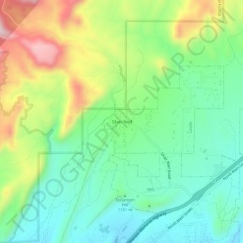
Nome: Mappa topografica Silver Reef, altitudine, rilievo.
Altitudine media: 1.185 m
Altitudine minima: 1.042 m
Altitudine massima: 1.455 m
Fai una donazione
Preparati per la tua prossima avventura:
In qualità di associato Amazon, questo sito riceve una commissione sugli acquisti idonei senza alcun costo aggiuntivo per te.