
Fai una donazione
Preparati per la tua prossima avventura:
In qualità di associato Amazon, questo sito riceve una commissione sugli acquisti idonei senza alcun costo aggiuntivo per te.
Mappa topografica Rice Hill
Clicca sulla mappa per visualizzare l'altitudine.
Fai una donazione
Preparati per la tua prossima avventura:
In qualità di associato Amazon, questo sito riceve una commissione sugli acquisti idonei senza alcun costo aggiuntivo per te.
A proposito di questa mappa
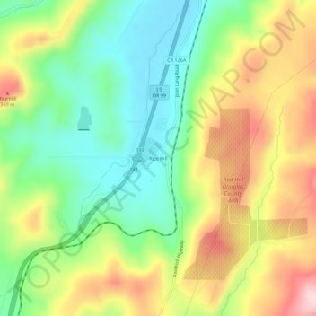
Nome: Mappa topografica Rice Hill, altitudine, rilievo.
Luogo: Rice Hill, Douglas County, Oregon, United States (43.51826 -123.30792 43.55826 -123.26792)
Altitudine media: 241 m
Altitudine minima: 120 m
Altitudine massima: 406 m
Fai una donazione
Preparati per la tua prossima avventura:
In qualità di associato Amazon, questo sito riceve una commissione sugli acquisti idonei senza alcun costo aggiuntivo per te.
Altre mappe topografiche
Clicca su una mappa per visualizzarne la topografia, l'altitudine e il rilievo.
Roseburg
United States > Oregon > Douglas County
Roseburg's elevation is approximately 500 feet (150 m). Its highest point is Mount Nebo, a 1,200-foot (370 m) hill to the west of Interstate 5. Through the 1980s, it was known for its band of 10-20 feral angora goats. Residents said they could predict the weather by watching where the goats were on the…
Altitudine media: 239 m
Fai una donazione
Preparati per la tua prossima avventura:
In qualità di associato Amazon, questo sito riceve una commissione sugli acquisti idonei senza alcun costo aggiuntivo per te.
Fai una donazione
Preparati per la tua prossima avventura:
In qualità di associato Amazon, questo sito riceve una commissione sugli acquisti idonei senza alcun costo aggiuntivo per te.
Roseburg
United States > Oregon > Douglas County
Roseburg's elevation is approximately 500 feet (150 m). Its highest point is Mount Nebo, a 1,200-foot (370 m) hill to the west of Interstate 5. Through the 1980s, it was known for its band of 10-20 feral angora goats. Residents said they could predict the weather by watching where the goats were on the…
Altitudine media: 239 m
Fai una donazione
Preparati per la tua prossima avventura:
In qualità di associato Amazon, questo sito riceve una commissione sugli acquisti idonei senza alcun costo aggiuntivo per te.
Elkton
United States > Oregon > Douglas County
According to the United States Census Bureau, the city has a total area of 0.26 square miles (0.67 km2), of which, 0.23 square miles (0.60 km2) is land and 0.03 square miles (0.08 km2) is water. The elevation is 141 feet (43 m).
Altitudine media: 95 m
Roseburg
United States > Oregon > Douglas County
Roseburg's elevation is approximately 500 feet (150 m). Its highest point is Mount Nebo, a 1,200-foot (370 m) hill to the west of Interstate 5. Through the 1980s, it was known for its band of 10-20 feral angora goats. Residents said they could predict the weather by watching where the goats were on the…
Altitudine media: 239 m
Fai una donazione
Preparati per la tua prossima avventura:
In qualità di associato Amazon, questo sito riceve una commissione sugli acquisti idonei senza alcun costo aggiuntivo per te.