
Fai una donazione
Preparati per la tua prossima avventura:
In qualità di associato Amazon, questo sito riceve una commissione sugli acquisti idonei senza alcun costo aggiuntivo per te.
Mappa topografica Santa Margarita
Clicca sulla mappa per visualizzare l'altitudine.
Fai una donazione
Preparati per la tua prossima avventura:
In qualità di associato Amazon, questo sito riceve una commissione sugli acquisti idonei senza alcun costo aggiuntivo per te.
A proposito di questa mappa
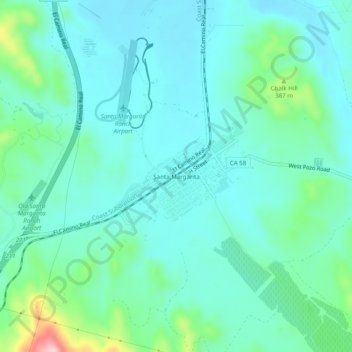
Nome: Mappa topografica Santa Margarita, altitudine, rilievo.
Altitudine media: 333 m
Altitudine minima: 290 m
Altitudine massima: 507 m
Fai una donazione
Preparati per la tua prossima avventura:
In qualità di associato Amazon, questo sito riceve una commissione sugli acquisti idonei senza alcun costo aggiuntivo per te.
Altre mappe topografiche
Clicca su una mappa per visualizzarne la topografia, l'altitudine e il rilievo.
Fai una donazione
Preparati per la tua prossima avventura:
In qualità di associato Amazon, questo sito riceve una commissione sugli acquisti idonei senza alcun costo aggiuntivo per te.
Cambria
United States > California > San Luis Obispo County > Cambria
Because lumber production, ranching activities and mercury mining increased in the area, the village adopted the more dignified name of Cambria. Locals seem to agree that the name was contributed by a local surveyor from Cambria County, Pennsylvania, because the local topography and flora reminded him of that…
Altitudine media: 58 m
Lake Nacimiento
United States > California > San Luis Obispo County > Heritage Ranch
Altitudine media: 312 m
Fai una donazione
Preparati per la tua prossima avventura:
In qualità di associato Amazon, questo sito riceve una commissione sugli acquisti idonei senza alcun costo aggiuntivo per te.
Paso Robles
United States > California > San Luis Obispo County
The topography of the area consists of gentle rolling hills on the eastern half of the city, and foothill peaks, which rise in elevation to the Santa Lucia Coastal Range on the west, which are all blanketed in the Californian chaparral environment, which is mainly dry grassland and oak woodland. Paso Robles…
Altitudine media: 297 m
Fai una donazione
Preparati per la tua prossima avventura:
In qualità di associato Amazon, questo sito riceve una commissione sugli acquisti idonei senza alcun costo aggiuntivo per te.
Fai una donazione
Preparati per la tua prossima avventura:
In qualità di associato Amazon, questo sito riceve una commissione sugli acquisti idonei senza alcun costo aggiuntivo per te.
Laguna Hills Park
United States > California > San Luis Obispo County > San Luis Obispo
Altitudine media: 82 m
Fai una donazione
Preparati per la tua prossima avventura:
In qualità di associato Amazon, questo sito riceve una commissione sugli acquisti idonei senza alcun costo aggiuntivo per te.
Cambria
United States > California > San Luis Obispo County
Originally an American settlement called Slab Town, the town later known as Cambria was centered at the Leffingwell cove of today's northern Moonstone Beach, which beach also featured a wharf. Because lumber production, ranching activities and mercury mining increased in the area, the village adopted the more…
Altitudine media: 58 m
Fai una donazione
Preparati per la tua prossima avventura:
In qualità di associato Amazon, questo sito riceve una commissione sugli acquisti idonei senza alcun costo aggiuntivo per te.
Guadalupe-Nipomo Dunes National Wildlife Refuge
United States > California > San Luis Obispo County
Altitudine media: 21 m
Paso Robles
United States > California > San Luis Obispo County
The topography of the area consists of gentle rolling hills on the eastern half of the city, and foothill peaks, which rise in elevation to the Santa Lucia Coastal Range on the west, which are all blanketed in the Californian chaparral environment, which is mainly dry grassland and oak woodland. Paso Robles…
Altitudine media: 297 m
Pike Place
United States > California > San Luis Obispo County > Oceano > Halcyon
Altitudine media: 25 m
Fai una donazione
Preparati per la tua prossima avventura:
In qualità di associato Amazon, questo sito riceve una commissione sugli acquisti idonei senza alcun costo aggiuntivo per te.
Fai una donazione
Preparati per la tua prossima avventura:
In qualità di associato Amazon, questo sito riceve una commissione sugli acquisti idonei senza alcun costo aggiuntivo per te.
Grover Beach
United States > California > San Luis Obispo County > Grover Beach
Altitudine media: 21 m