
Fai una donazione
Preparati per la tua prossima avventura:
In qualità di associato Amazon, questo sito riceve una commissione sugli acquisti idonei senza alcun costo aggiuntivo per te.
Mappa topografica Altamira
Clicca sulla mappa per visualizzare l'altitudine.
Fai una donazione
Preparati per la tua prossima avventura:
In qualità di associato Amazon, questo sito riceve una commissione sugli acquisti idonei senza alcun costo aggiuntivo per te.
Altamira
Altamira is a small pueblo in the department Huila, with a population around 2,416. Its geographical coordinates are 2° 3' 46" North, 75° 47' 14" West. It is about an 8-hour bus trip south of Bogota. The largest city in Huila and its capital is Neiva, which is 89 miles north, with a population of about 370,000. The highway is two lane and paved. It is located in the Eastern Range of the Andes Mountains at about 3,540 feet elevation. The Central Range of the Andes converges in this part of the country so the mountains of that range can be seen just north of the town. On a very clear day when there are no high altitude clouds obscuring the view, the volcano Nevado de Huila can be seen to the north. At 5365 m (17601 ft) tall, it is the highest volcano in the country and is permanently snow covered with a glacier and it stands out well on a clear day even though it is about 50 miles north of Altamira.
Fai una donazione
Preparati per la tua prossima avventura:
In qualità di associato Amazon, questo sito riceve una commissione sugli acquisti idonei senza alcun costo aggiuntivo per te.
A proposito di questa mappa
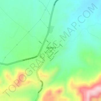
Nome: Mappa topografica Altamira, altitudine, rilievo.
Luogo: Altamira, Centro, Huila, Colombia (2.05883 -75.79351 2.06843 -75.78318)
Altitudine media: 1.032 m
Altitudine minima: 936 m
Altitudine massima: 1.209 m
Fai una donazione
Preparati per la tua prossima avventura:
In qualità di associato Amazon, questo sito riceve una commissione sugli acquisti idonei senza alcun costo aggiuntivo per te.