Geolocalizza

Mappa topografica Harsil

Clicca sulla mappa per visualizzare l'altitudine.

A proposito di questa mappa

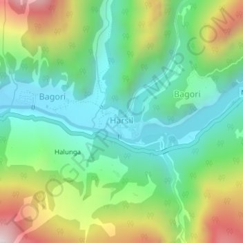
Nome: Mappa topografica Harsil, altitudine, rilievo.

Luogo: Harsil, Bhatwari, Uttarkashi, Uttarakhand, India (31.03390 78.74709 31.03965 78.75525)

Altitudine media: 2.761 m

Altitudine minima: 2.464 m

Altitudine massima: 3.350 m

Altre mappe topografiche

Clicca su una mappa per visualizzarne la topografia, l'altitudine e il rilievo.

Malla

India > Uttarakhand > Bhatwari

Altitudine media: 1.911 m

Taknaur Renge

India > Uttarakhand > Bhatwari

Altitudine media: 1.811 m

Uttarkashi

India > Uttarakhand > Bhatwari

It is the district headquarters of Uttarkashi district. Uttarkashi is situated on the banks of river Bhagirathi at an altitude of 1158 m above sea level. Uttarkashi is generally known as a holy town close to Rishikesh. It is located in the state of Uttarakhand in India. Uttarkashi is home to a number of…

Altitudine media: 1.619 m

Dharali

India > Uttarakhand > Bhatwari

Altitudine media: 2.977 m

Raithal

India > Uttarakhand > Bhatwari

Altitudine media: 2.122 m

Salang

India > Uttarakhand > Bhatwari

Altitudine media: 2.172 m

Bagori

India > Uttarakhand > Bhatwari

Altitudine media: 2.955 m

Gangotri

India > Uttarakhand > Bhatwari

Altitudine media: 4.139 m

Darwa

India > Uttarakhand > Bhatwari

Altitudine media: 3.726 m

Bhankoli

India > Uttarakhand > Bhatwari

Altitudine media: 2.191 m

Mastari

India > Uttarakhand > Bhatwari > Thalan

Altitudine media: 1.646 m

Gomukh, Ice Cave

India > Uttarakhand > Bhatwari

Around the snout, nature presents a wild topography. There are boulders scattered here and there with some pieces of broken snow, along with the hard clayey snow of the glacier.

Altitudine media: 4.286 m

Sudarshan Parbat

India > Uttarakhand > Bhatwari

Sudarshan Parbat is a mountain of the Garhwal Himalaya in Uttarakhand India.The elevation of Sudarshan Parbat is 6,529 metres (21,421 ft) and its prominence is 456 metres (1,496 ft). It is joint 87th highest located entirely within the Uttrakhand. Nanda Devi, is the highest mountain in this category. Sudarshan…

Altitudine media: 5.792 m

Sungar

India > Uttarakhand > Bhatwari > Sungar

Altitudine media: 2.433 m

Meru North

India > Uttarakhand > Bhatwari

Altitudine media: 5.744 m

Mandav

India > Uttarakhand > Bhatwari > Uttarkashi > Mandav

Altitudine media: 1.495 m

Dharali

India > Uttarakhand > Bhatwari

Altitudine media: 2.977 m

Raithal

India > Uttarakhand > Bhatwari

Altitudine media: 2.122 m

Kumalti

India > Uttarakhand > Bhatwari

Altitudine media: 1.853 m

Raithal

India > Uttarakhand > Bhatwari

Altitudine media: 2.122 m

Preparati per la tua prossima avventura:

🧥Piumini Compattabili - Giacche calde che occupano pochissimo spazio nello zaino
🍳Pentole da campeggio - Set compatti per cucina outdoor
🥾Scarponi da Trekking - Calzature robuste e impermeabili per ogni tipo di sentiero e terreno
🧥Poncho Anti-pioggia - Protezione rapida e totale che copre anche lo zaino
🕶️Occhiali da sole montagna - Protezione UV per alta quota

In qualità di associato Amazon, questo sito riceve una commissione sugli acquisti idonei senza alcun costo aggiuntivo per te.