
Fai una donazione
Preparati per la tua prossima avventura:
In qualità di associato Amazon, questo sito riceve una commissione sugli acquisti idonei senza alcun costo aggiuntivo per te.
Mappa topografica Harz
Clicca sulla mappa per visualizzare l'altitudine.
Fai una donazione
Preparati per la tua prossima avventura:
In qualità di associato Amazon, questo sito riceve una commissione sugli acquisti idonei senza alcun costo aggiuntivo per te.
Harz
The Harz (German: [haːɐ̯ts] (listen)) is a highland area in northern Germany. It has the highest elevations for that region, and its rugged terrain extends across parts of Lower Saxony, Saxony-Anhalt, and Thuringia. The name Harz derives from the Middle High German word Hardt or Hart (hill forest). The name Hercynia derives from a Celtic name and could refer to other mountain forests, but has also been applied to the geology of the Harz. The Brocken is the highest summit in the Harz with an elevation of 1,141.1 metres (3,744 ft) above sea level. The Wurmberg (971 metres (3,186 ft)) is the highest peak located entirely within the state of Lower Saxony.
Fai una donazione
Preparati per la tua prossima avventura:
In qualità di associato Amazon, questo sito riceve una commissione sugli acquisti idonei senza alcun costo aggiuntivo per te.
A proposito di questa mappa
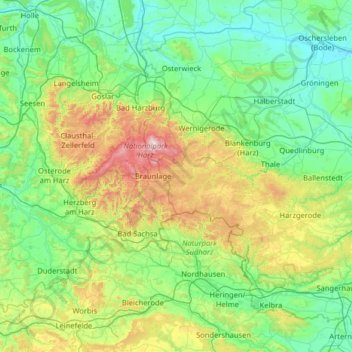
Nome: Mappa topografica Harz, altitudine, rilievo.
Luogo: Harz, Saxony-Anhalt, Germany (51.49477 10.18402 51.95506 11.46491)
Altitudine media: 280 m
Altitudine minima: 75 m
Altitudine massima: 1.139 m
Fai una donazione
Preparati per la tua prossima avventura:
In qualità di associato Amazon, questo sito riceve una commissione sugli acquisti idonei senza alcun costo aggiuntivo per te.
Altre mappe topografiche
Clicca su una mappa per visualizzarne la topografia, l'altitudine e il rilievo.
Brocken
Germany > Saxony-Anhalt > Landkreis Harz > Wernigerode
The Brocken (German pronunciation: [ˈbʁɔkn̩] ), also sometimes referred to as the Blocksberg, is a 1,141 m (3,743 ft) mountain near Schierke in the German state of Saxony-Anhalt, between the rivers Weser and Elbe. The highest peak in the Harz mountain range, and in Northern Germany, it is subalpine, yet…
Altitudine media: 963 m
Dessau
Germany > Saxony-Anhalt > Dessau-Roßlau
Dessau is situated on a floodplain where the Mulde flows into the Elbe. This causes yearly floods. The worst flood took place in the year 2002, when the Waldersee district was nearly completely flooded. The south of Dessau touches a well-wooded area called Mosigkauer Heide. The highest elevation is a 110 m…
Altitudine media: 62 m
Fai una donazione
Preparati per la tua prossima avventura:
In qualità di associato Amazon, questo sito riceve una commissione sugli acquisti idonei senza alcun costo aggiuntivo per te.
Fai una donazione
Preparati per la tua prossima avventura:
In qualità di associato Amazon, questo sito riceve una commissione sugli acquisti idonei senza alcun costo aggiuntivo per te.
Dessau
Germany > Saxony-Anhalt > Dessau-Roßlau
Dessau is situated on a floodplain where the Mulde flows into the Elbe. This causes yearly floods. The worst flood took place in the year 2002, when the Waldersee district was nearly completely flooded. The south of Dessau touches a well-wooded area called Mosigkauer Heide. The highest elevation is a 110 m…
Altitudine media: 62 m
Brocken
Germany > Saxony-Anhalt > Landkreis Harz > Wernigerode
The Brocken (German pronunciation: [ˈbʁɔkn̩] ), also sometimes referred to as the Blocksberg, is a 1,141 m (3,743 ft) mountain near Schierke in the German state of Saxony-Anhalt, between the rivers Weser and Elbe. The highest peak in the Harz mountain range, and in Northern Germany, it is subalpine, yet…
Altitudine media: 963 m
Fai una donazione
Preparati per la tua prossima avventura:
In qualità di associato Amazon, questo sito riceve una commissione sugli acquisti idonei senza alcun costo aggiuntivo per te.
Fai una donazione
Preparati per la tua prossima avventura:
In qualità di associato Amazon, questo sito riceve una commissione sugli acquisti idonei senza alcun costo aggiuntivo per te.
Tromsdorf
Germany > Saxony-Anhalt > Burgenlandkreis > Eckartsberga > Tromsdorf
Altitudine media: 195 m
Fai una donazione
Preparati per la tua prossima avventura:
In qualità di associato Amazon, questo sito riceve una commissione sugli acquisti idonei senza alcun costo aggiuntivo per te.
Aschersleben
Germany > Saxony-Anhalt > Salzlandkreis > Aschersleben > Aschersleben
Altitudine media: 139 m
Fai una donazione
Preparati per la tua prossima avventura:
In qualità di associato Amazon, questo sito riceve una commissione sugli acquisti idonei senza alcun costo aggiuntivo per te.