
Fai una donazione
Preparati per la tua prossima avventura:
In qualità di associato Amazon, questo sito riceve una commissione sugli acquisti idonei senza alcun costo aggiuntivo per te.
Mappa topografica Union Grove
Clicca sulla mappa per visualizzare l'altitudine.
Fai una donazione
Preparati per la tua prossima avventura:
In qualità di associato Amazon, questo sito riceve una commissione sugli acquisti idonei senza alcun costo aggiuntivo per te.
Union Grove
Union Grove is located in western Marshall County at 34°24′0″N 86°26′46″W / 34.40000°N 86.44611°W / 34.40000; -86.44611 (34.400088, -86.446049). It is 7 miles (11 km) northeast of Arab and 5 miles (8 km) southwest of Guntersville Dam on the Tennessee River. Union Grove sits at an elevation of 1,040 feet (320 m) above sea level on the relatively flat top of Brindley Mountain, near the southwest end of the Appalachian Plateau. Electricity service in Union Grove is provided through Arab Electric Cooperative, which comes through the Tennessee Valley Authority.
Fai una donazione
Preparati per la tua prossima avventura:
In qualità di associato Amazon, questo sito riceve una commissione sugli acquisti idonei senza alcun costo aggiuntivo per te.
A proposito di questa mappa
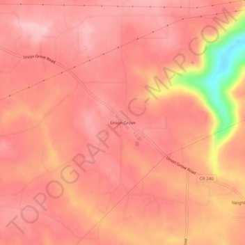
Nome: Mappa topografica Union Grove, altitudine, rilievo.
Luogo: Union Grove, Marshall County, Alabama, United States (34.38176 -86.46915 34.42176 -86.42915)
Altitudine media: 300 m
Altitudine minima: 170 m
Altitudine massima: 335 m
Fai una donazione
Preparati per la tua prossima avventura:
In qualità di associato Amazon, questo sito riceve una commissione sugli acquisti idonei senza alcun costo aggiuntivo per te.