
Mappa topografica Franklin
Mappa interattiva
Clicca sulla mappa per visualizzare l'altitudine.
A proposito di questa mappa
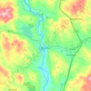
Nome: Mappa topografica Franklin, altitudine, rilievo.
Altitudine media: 201 m
Altitudine minima: 76 m
Altitudine massima: 431 m
According to the United States Census Bureau, the city has a total area of 29.1 square miles (75.4 km2), of which 27.3 square miles (70.7 km2) is land and 1.9 square miles (4.9 km2) is water, comprising 6.31% of the town. It is drained by the Winnipesaukee, Pemigewasset and Merrimack rivers. Webster Lake is in the north. The highest point in Franklin is an unnamed summit near the northwestern corner of the city limits, where the elevation reaches approximately 1,370 feet (420 m) above sea level. Franklin lies fully within the Merrimack River watershed.