
Fai una donazione
Preparati per la tua prossima avventura:
In qualità di associato Amazon, questo sito riceve una commissione sugli acquisti idonei senza alcun costo aggiuntivo per te.
Mappa topografica Seaside
Clicca sulla mappa per visualizzare l'altitudine.
Fai una donazione
Preparati per la tua prossima avventura:
In qualità di associato Amazon, questo sito riceve una commissione sugli acquisti idonei senza alcun costo aggiuntivo per te.
Seaside
Seaside, formerly East Monterey, is a city in Monterey County, California, United States, with a population of 32,366 as of the 2020 census. It is located 2.25 miles (3.6 km) east-northeast of Monterey, at an elevation of 33 feet (10 m), and is the home of California State University, Monterey Bay (CSUMB), UC MBEST Center, and the Monterey College of Law, which are located on the site of the former military base Fort Ord. Also on the site are the Bayonet and Black Horse golf courses, now open to the public and host to PGA Tour events, including the 2012 PGA Professional National Championship. Seaside is the gateway to Fort Ord National Monument, created on April 20, 2012.
Fai una donazione
Preparati per la tua prossima avventura:
In qualità di associato Amazon, questo sito riceve una commissione sugli acquisti idonei senza alcun costo aggiuntivo per te.
A proposito di questa mappa
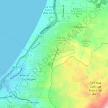
Nome: Mappa topografica Seaside, altitudine, rilievo.
Luogo: Seaside, Monterey County, California, 93955, United States (36.59681 -121.87991 36.65474 -121.78988)
Altitudine media: 69 m
Altitudine minima: -7 m
Altitudine massima: 275 m
Fai una donazione
Preparati per la tua prossima avventura:
In qualità di associato Amazon, questo sito riceve una commissione sugli acquisti idonei senza alcun costo aggiuntivo per te.
Altre mappe topografiche
Clicca su una mappa per visualizzarne la topografia, l'altitudine e il rilievo.
Big Sur
United States > California > Monterey County
The highest peaks of the crest of the coast range are located at an average distance from the coast of three and a half miles [5.6 km]. In this distance they rise to elevations of from three thousand six hundred to five thousand feet [1,100 to 1,500 m] above the sea-level. From San Carpoforo Creek to…
Altitudine media: 193 m
Fai una donazione
Preparati per la tua prossima avventura:
In qualità di associato Amazon, questo sito riceve una commissione sugli acquisti idonei senza alcun costo aggiuntivo per te.
Gorda
United States > California > Monterey County
Gorda (Spanish for "Fat") is a hamlet in Monterey County, California. It is located 3 mi (4.8 km) south of Cape San Martin, at an elevation of 148 ft (45 m). It is one of the three small settlements of filling stations, restaurants, and motels located along State Route 1 on the Big Sur coast. The ZIP Code is…
Altitudine media: 168 m
Fai una donazione
Preparati per la tua prossima avventura:
In qualità di associato Amazon, questo sito riceve una commissione sugli acquisti idonei senza alcun costo aggiuntivo per te.
Posts
United States > California > Monterey County
Posts (formerly Posts Summit) is an unincorporated community in the Big Sur region of Monterey County, California. It is located on the Big Sur Coast Highway, 4.8 miles (7.7 km) south of the Big Sur Village at an elevation of 945 feet (288 m).
Altitudine media: 251 m
Lockwood
United States > California > Monterey County
Lockwood is in southern Monterey County, 6 miles (10 km) east-southeast of Jolon, 1.8 miles (2.9 km) north of the mouth of Tule Canyon, 3.0 miles (4.8 km) north of the San Antonio River, and 9.3 miles (15.0 km) north of Bryson, at an elevation of 971 feet (296 m). It is 9 miles (14 km) northwest of Lake San…
Altitudine media: 307 m
Fai una donazione
Preparati per la tua prossima avventura:
In qualità di associato Amazon, questo sito riceve una commissione sugli acquisti idonei senza alcun costo aggiuntivo per te.
Fai una donazione
Preparati per la tua prossima avventura:
In qualità di associato Amazon, questo sito riceve una commissione sugli acquisti idonei senza alcun costo aggiuntivo per te.
David Cutino Park
United States > California > Monterey County > Seaside > Del Monte Heights
Altitudine media: 35 m
Fai una donazione
Preparati per la tua prossima avventura:
In qualità di associato Amazon, questo sito riceve una commissione sugli acquisti idonei senza alcun costo aggiuntivo per te.
Big Sur
United States > California > Monterey County
The highest peaks of the crest of the coast range are located at an average distance from the coast of three and a half miles [5.6 km]. In this distance they rise to elevations of from three thousand six hundred to five thousand feet [1,100 to 1,500 m] above the sea-level. From San Carpoforo Creek to…
Altitudine media: 193 m
Fai una donazione
Preparati per la tua prossima avventura:
In qualità di associato Amazon, questo sito riceve una commissione sugli acquisti idonei senza alcun costo aggiuntivo per te.
Prunedale
United States > California > Monterey County
Prunedale is a census-designated place in Monterey County, California, United States. It is located 8 miles (13 km) north of Salinas at an elevation of 92 feet (28 m). The population was 18,885 as of the 2020 census, up from 17,560 in 2010. Plum trees were grown in Prunedale in the early days of its founding,…
Altitudine media: 69 m
Fai una donazione
Preparati per la tua prossima avventura:
In qualità di associato Amazon, questo sito riceve una commissione sugli acquisti idonei senza alcun costo aggiuntivo per te.
Las Lomas
United States > California > Monterey County > Las Lomas > Hutchings Gate
Las Lomas (Spanish for 'The Hills') is an unincorporated community and census-designated place (CDP) in Monterey County, California, United States. Las Lomas is located 7 miles (11 km) north-northwest of Prunedale. The elevation is 43 feet (13 m). The population was 3,046 at the 2020 census.
Altitudine media: 35 m
Point Sur Lighthouse
United States > California > Monterey County > Big Sur Village
Altitudine media: 11 m
Fai una donazione
Preparati per la tua prossima avventura:
In qualità di associato Amazon, questo sito riceve una commissione sugli acquisti idonei senza alcun costo aggiuntivo per te.
Fai una donazione
Preparati per la tua prossima avventura:
In qualità di associato Amazon, questo sito riceve una commissione sugli acquisti idonei senza alcun costo aggiuntivo per te.
Carmel Pinnacles State Marine Reserve
United States > California > Monterey County > Del Monte Forest
Altitudine media: 2 m
King City
United States > California > Monterey County
King City (variants: Kings City, City of King) is a city in Monterey County, California, United States. It is located on the Salinas River 51 miles (82 km) southeast of Salinas, at an elevation of 335 feet (102 m). It lies along U.S. Route 101 in the Salinas Valley of California's Central Coast. King City is a…
Altitudine media: 102 m
Fai una donazione
Preparati per la tua prossima avventura:
In qualità di associato Amazon, questo sito riceve una commissione sugli acquisti idonei senza alcun costo aggiuntivo per te.
Fai una donazione
Preparati per la tua prossima avventura:
In qualità di associato Amazon, questo sito riceve una commissione sugli acquisti idonei senza alcun costo aggiuntivo per te.