
Fai una donazione
Preparati per la tua prossima avventura:
In qualità di associato Amazon, questo sito riceve una commissione sugli acquisti idonei senza alcun costo aggiuntivo per te.
Mappa topografica Longview
Clicca sulla mappa per visualizzare l'altitudine.
Fai una donazione
Preparati per la tua prossima avventura:
In qualità di associato Amazon, questo sito riceve una commissione sugli acquisti idonei senza alcun costo aggiuntivo per te.
Longview
Longview, located in Cowlitz County, Washington, is situated within a distinct topographical region. The city lies at a relatively low elevation along the Columbia River, averaging around 15 feet (5 meters) above sea level. It sits within a broad, flat valley bordered by gently rolling hills, and is impacted by the Columbia River Gorge to the north, which influences both the climate and terrain. The surrounding land features ridges and small mountainous areas, with some local elevations reaching up to 1,300 feet (396 meters). The terrain varies from flat plains near the river to higher, forested slopes, making it a unique blend of riverfront and elevated areas. The region's topography is characterized by its proximity to several rivers, including the Cowlitz River and the Columbia River, shaping the landscape and local environment.
Fai una donazione
Preparati per la tua prossima avventura:
In qualità di associato Amazon, questo sito riceve una commissione sugli acquisti idonei senza alcun costo aggiuntivo per te.
A proposito di questa mappa
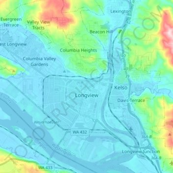
Nome: Mappa topografica Longview, altitudine, rilievo.
Luogo: Longview, Cowlitz County, Washington, 98632, United States (46.10101 -123.03939 46.18358 -122.89172)
Altitudine media: 50 m
Altitudine minima: -5 m
Altitudine massima: 366 m
Fai una donazione
Preparati per la tua prossima avventura:
In qualità di associato Amazon, questo sito riceve una commissione sugli acquisti idonei senza alcun costo aggiuntivo per te.
Altre mappe topografiche
Clicca su una mappa per visualizzarne la topografia, l'altitudine e il rilievo.
Toutle River Sediment Retention Structure
United States > Washington > Cowlitz County
Altitudine media: 347 m
Toutle River Sediment Retention Structure
United States > Washington > Cowlitz County
Altitudine media: 347 m
Fai una donazione
Preparati per la tua prossima avventura:
In qualità di associato Amazon, questo sito riceve una commissione sugli acquisti idonei senza alcun costo aggiuntivo per te.