
Fai una donazione
Preparati per la tua prossima avventura:
In qualità di associato Amazon, questo sito riceve una commissione sugli acquisti idonei senza alcun costo aggiuntivo per te.
Mappa topografica Bell Island
Clicca sulla mappa per visualizzare l'altitudine.
Fai una donazione
Preparati per la tua prossima avventura:
In qualità di associato Amazon, questo sito riceve una commissione sugli acquisti idonei senza alcun costo aggiuntivo per te.
Bell Island
The coast is very rocky and consists almost entirely of steep cliffs tens of meters high that tower up to 45 kilometres (28 mi) above sea level. The island, which continues to gain in altitude especially close to the coastline, reaches a maximum height of 148 metres (486 ft). Because the central part of the island is relatively flat compared to the coast, seen from the sea it has a somewhat table mountain-like view. Since the island is so high above sea level, on a clear day there are excellent views of the Newfoundland mainland from either side. The cliffs are home to several sea caves and natural bridges and in several places overlook large rocks and sea stacks. Known are The Bell, Coadys Island and The Clapper, all on the southwest coast. There is also a ravine on the east coast that is known as The Scrape. The Front and Lance Cove are almost the only places where the coast is less steep and where you can land from the sea. To the north are Redmans Head and Eastern Head, two prominent capes between which a lighthouse has been built.
Fai una donazione
Preparati per la tua prossima avventura:
In qualità di associato Amazon, questo sito riceve una commissione sugli acquisti idonei senza alcun costo aggiuntivo per te.
A proposito di questa mappa
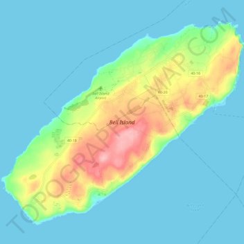
Nome: Mappa topografica Bell Island, altitudine, rilievo.
Altitudine media: 30 m
Altitudine minima: -1 m
Altitudine massima: 141 m
Fai una donazione
Preparati per la tua prossima avventura:
In qualità di associato Amazon, questo sito riceve una commissione sugli acquisti idonei senza alcun costo aggiuntivo per te.