
Fai una donazione
Preparati per la tua prossima avventura:
In qualità di associato Amazon, questo sito riceve una commissione sugli acquisti idonei senza alcun costo aggiuntivo per te.
Mappa topografica Ono Island
Clicca sulla mappa per visualizzare l'altitudine.
Fai una donazione
Preparati per la tua prossima avventura:
In qualità di associato Amazon, questo sito riceve una commissione sugli acquisti idonei senza alcun costo aggiuntivo per te.
Ono Island
Ono Island was along the boundary of the treaties between France and Spain. In 1813, after protests and attempts at rebellion, President James Monroe seized Spanish lands west of the Perdido River and declared them a part of the Louisiana Purchase of 1803. This set the east end of the Island, Perdido Key, at the mouth of the Perdido River, as the boundary between the United States and Spain. That same boundary would later mark the boundary between Alabama and Florida. Ono Island has previously been known as "Goat Island" or "George Kee's Island". George Kee, a caretaker for land belonging to Fred Scott. Scott was an early developer in the Perdido Key area and acquired Ono Island (alongside Innerarity point and other land) via Spanish land grants in the 1820s. Scott brought in goats and allowed them to roam free until there were an estimated 2,000 goats on the island, plus the wild hogs that Kee allowed anyone to shoot for food. At that time, the island was uninhabited except a small house Kee occupied that he built himself. A hurricane in 1916 changed the topography of the island by closing the Key and creating a new opening on the western end of the island. When Florida attempted to claim the land between the old pass and the new, Alabama legislators replied "Oh no you don't." That gave rise to the name, Ono Island.
Fai una donazione
Preparati per la tua prossima avventura:
In qualità di associato Amazon, questo sito riceve una commissione sugli acquisti idonei senza alcun costo aggiuntivo per te.
A proposito di questa mappa
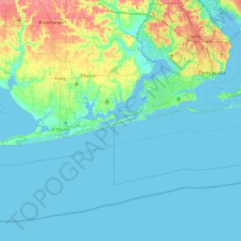
Nome: Mappa topografica Ono Island, altitudine, rilievo.
Luogo: Ono Island, Baldwin County, Alabama, United States (30.27353 -87.51748 30.31353 -87.47748)
Altitudine media: 1 m
Altitudine minima: -4 m
Altitudine massima: 22 m
Fai una donazione
Preparati per la tua prossima avventura:
In qualità di associato Amazon, questo sito riceve una commissione sugli acquisti idonei senza alcun costo aggiuntivo per te.
Altre mappe topografiche
Clicca su una mappa per visualizzarne la topografia, l'altitudine e il rilievo.
Daphne
United States > Alabama > Baldwin County
The topography of Daphne is quite consistent from a gently sloping sea level on the west to low rolling hills further east. Generally, the entire city lies no more than 150 feet above sea level. The land along the Daphne bay coast, like other land throughout the county, is rich with sandy-loam type soils.
Altitudine media: 25 m
Fai una donazione
Preparati per la tua prossima avventura:
In qualità di associato Amazon, questo sito riceve una commissione sugli acquisti idonei senza alcun costo aggiuntivo per te.
Gulf Shores
United States > Alabama > Baldwin County
Jack Edwards National Airport is located in Gulf Shores and offers services from Gulf Air Center, Salt Air Aviation Center and Platium Air Center. The airport is located in town, two miles from the beach. Their FBO Gulf Air Center will provide a rental vehicle while they take care of fueling and storing…
Altitudine media: 5 m
Fairhope
United States > Alabama > Baldwin County
According to the U.S. Census Bureau, the city has a total area of 12.0 square miles (31.1 km2), of which 0.019 square mile (0.05 km2), or 0.16%, is water. Its elevation ranges from sea level at the bay to 122 feet (37 m) in the city center.
Altitudine media: 17 m
Fai una donazione
Preparati per la tua prossima avventura:
In qualità di associato Amazon, questo sito riceve una commissione sugli acquisti idonei senza alcun costo aggiuntivo per te.
Summerdale
United States > Alabama > Baldwin County
The Navy Outlying Landing Field (NOLF) Summerdale airport is on the east side of Summerdale (at latitude, longitude: 30.507695, –87.645541). The Airport Code is NFD, in region: ASO - Southern, with boundary ARTCC: ZJX - Jacksonville, and Tie-in FSS: ANB - Anniston. The airport runway length/width is 2850 x…
Altitudine media: 32 m
Fai una donazione
Preparati per la tua prossima avventura:
In qualità di associato Amazon, questo sito riceve una commissione sugli acquisti idonei senza alcun costo aggiuntivo per te.
Daphne
United States > Alabama > Baldwin County
The topography of Daphne is quite consistent from a gently sloping sea level on the west to low rolling hills further east. Generally, the entire city lies no more than 150 feet above sea level. The land along the Daphne bay coast, like other land throughout the county, is rich with sandy-loam type soils.
Altitudine media: 25 m
Fairhope
United States > Alabama > Baldwin County
According to the U.S. Census Bureau, the city has a total area of 12.0 square miles (31.1 km2), of which 0.019 square mile (0.05 km2), or 0.16%, is water. Its elevation ranges from sea level at the bay to 122 feet (37 m) in the city center.
Altitudine media: 17 m
Gulf Shores
United States > Alabama > Baldwin County
Jack Edwards National Airport is located in Gulf Shores and offers services from Gulf Air Center, Salt Air Aviation Center and Platium Air Center. The airport is located in town, two miles from the beach. Their FBO Gulf Air Center will provide a rental vehicle while they take care of fueling and storing…
Altitudine media: 5 m
Fai una donazione
Preparati per la tua prossima avventura:
In qualità di associato Amazon, questo sito riceve una commissione sugli acquisti idonei senza alcun costo aggiuntivo per te.
Summerdale
United States > Alabama > Baldwin County
The Navy Outlying Landing Field (NOLF) Summerdale airport is on the east side of Summerdale (at latitude, longitude: 30.507695, –87.645541). The Airport Code is NFD, in region: ASO - Southern, with boundary ARTCC: ZJX - Jacksonville, and Tie-in FSS: ANB - Anniston. The airport runway length/width is 2850 x…
Altitudine media: 32 m
Bon Secour
United States > Alabama > Baldwin County > Bon Secour
Bon Secour lies on the Bon Secour River. Elevation is 10 feet (3.0 m) above sea level. The estuarial river system empties into Bon Secour Bay at Mobile Bay.
Altitudine media: 6 m
Fai una donazione
Preparati per la tua prossima avventura:
In qualità di associato Amazon, questo sito riceve una commissione sugli acquisti idonei senza alcun costo aggiuntivo per te.
Fai una donazione
Preparati per la tua prossima avventura:
In qualità di associato Amazon, questo sito riceve una commissione sugli acquisti idonei senza alcun costo aggiuntivo per te.
Fai una donazione
Preparati per la tua prossima avventura:
In qualità di associato Amazon, questo sito riceve una commissione sugli acquisti idonei senza alcun costo aggiuntivo per te.
Daphne
United States > Alabama > Baldwin County
The topography of Daphne is quite consistent from a gently sloping sea level on the west to low rolling hills further east. Generally, the entire city lies no more than 150 feet above sea level. The land along the Daphne bay coast, like other land throughout the county, is rich with sandy-loam type soils.
Altitudine media: 25 m
Fai una donazione
Preparati per la tua prossima avventura:
In qualità di associato Amazon, questo sito riceve una commissione sugli acquisti idonei senza alcun costo aggiuntivo per te.
Fairhope
United States > Alabama > Baldwin County
According to the U.S. Census Bureau, the city has a total area of 12.0 square miles (31.1 km2), of which 0.019 square mile (0.05 km2), or 0.16%, is water.[2] Its elevation ranges from sea level at the bay to 122 feet (37 m) in the city center.[11]
Altitudine media: 17 m