
Mappa topografica Lone Tree
Clicca sulla mappa per visualizzare l'altitudine.
Lone Tree
Lone Tree is located on the northern border of Douglas County, directly adjacent to Arapahoe County, approximately 18 miles (29 km) south of downtown Denver. Neighboring communities include Centennial to the north, Highlands Ranch to the west, and Parker to the southeast. The Meridian International Business Center, a major office and business park, lies immediately north of the city in unincorporated Arapahoe County. According to the United States Census Bureau, the city has a total area of 9.81 square miles (25.4 km²), all of it land, at an elevation of 6,010 feet (1,832 m).
A proposito di questa mappa
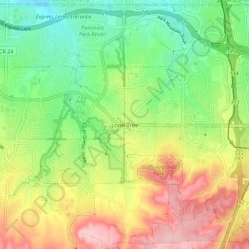
Nome: Mappa topografica Lone Tree, altitudine, rilievo.
Luogo: Lone Tree, Douglas County, Colorado, 80124, United States (39.50710 -104.90935 39.56648 -104.82991)
Altitudine media: 1.818 m
Altitudine minima: 1.730 m
Altitudine massima: 1.938 m
Altre mappe topografiche
Clicca su una mappa per visualizzarne la topografia, l'altitudine e il rilievo.
Hidden Mesa Open Space
United States > Colorado > Douglas County > Castle Rock
Altitudine media: 1.902 m