
Mappa topografica Warmley
Mappa interattiva
Clicca sulla mappa per visualizzare l'altitudine.
A proposito di questa mappa
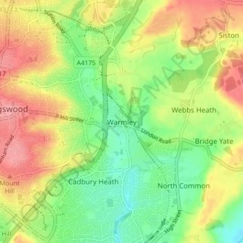
Nome: Mappa topografica Warmley, altitudine, rilievo.
Altitudine media: 69 m
Altitudine minima: 27 m
Altitudine massima: 116 m
Altre mappe topografiche
Clicca su una mappa per visualizzarne la topografia, l'altitudine e il rilievo.
Marsh Common
United Kingdom > England > South Gloucestershire > Easter Compton
Marsh Common, Pilning and Severn Beach, Easter Compton, South Gloucestershire, West of England, England, BS35 4JU, United Kingdom
Altitudine media: 10 m
Yate
United Kingdom > England > South Gloucestershire
Yate, South Gloucestershire, West of England, England, United Kingdom
Altitudine media: 83 m
Siston
United Kingdom > England > South Gloucestershire
Siston, South Gloucestershire, West of England, England, United Kingdom
Altitudine media: 80 m
Rangeworthy
United Kingdom > England > South Gloucestershire
Rangeworthy, South Gloucestershire, West of England, England, United Kingdom
Altitudine media: 59 m
Alveston
United Kingdom > England > South Gloucestershire
Alveston, South Gloucestershire, West of England, England, United Kingdom
Altitudine media: 75 m
Kingswood
United Kingdom > England > South Gloucestershire
Kingswood, South Gloucestershire, West of England, England, BS15 8LQ, United Kingdom
Altitudine media: 57 m