
Mappa topografica East Greenwich
Mappa interattiva
Clicca sulla mappa per visualizzare l'altitudine.
A proposito di questa mappa
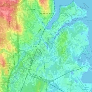
Nome: Mappa topografica East Greenwich, altitudine, rilievo.
Altitudine media: 21 m
Altitudine minima: -6 m
Altitudine massima: 86 m
Altre mappe topografiche
Clicca su una mappa per visualizzarne la topografia, l'altitudine e il rilievo.
Anthony
United States > Rhode Island > Kent County > Coventry
Anthony, Coventry, Kent County, Rhode Island, 02816, United States
Altitudine media: 71 m
Coventry
United States > Rhode Island > Kent County
Coventry, Kent County, Rhode Island, United States
Altitudine media: 126 m
Apponaug
United States > Rhode Island > Kent County
Apponaug, Kent County, Rhode Island, 02886, United States
Altitudine media: 23 m
Crompton
United States > Rhode Island > Kent County > West Warwick
Crompton, West Warwick, Kent County, Rhode Island, 02893, United States
Altitudine media: 63 m
West Greenwich
United States > Rhode Island > Kent County > West Greenwich
West Greenwich, Kent County, Rhode Island, 02817, United States
Altitudine media: 111 m
Warwick
United States > Rhode Island > Kent County
Warwick, Kent County, Rhode Island, United States
Altitudine media: 34 m