
Mappa topografica Malton
Mappa interattiva
Clicca sulla mappa per visualizzare l'altitudine.
Malton
As with the rest of the British Isles and Yorkshire, Malton possesses a maritime climate with cool summers and mild winters. The nearest Met Office weather station for which records are available is High Mowthorpe, about 6 miles (10 km) east of the town centre. Due to its lower elevation, the town centre is likely to be marginally warmer than High Mowthorpe throughout the year.
A proposito di questa mappa
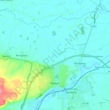
Nome: Mappa topografica Malton, altitudine, rilievo.
Altitudine media: 28 m
Altitudine minima: 15 m
Altitudine massima: 91 m