
Fai una donazione
Preparati per la tua prossima avventura:
In qualità di associato Amazon, questo sito riceve una commissione sugli acquisti idonei senza alcun costo aggiuntivo per te.
Mappa topografica Ann Arbor
Clicca sulla mappa per visualizzare l'altitudine.
Fai una donazione
Preparati per la tua prossima avventura:
In qualità di associato Amazon, questo sito riceve una commissione sugli acquisti idonei senza alcun costo aggiuntivo per te.
Ann Arbor
Ann Arbor is 11.2 miles (18.0 km) road miles west of Ypsilanti. Ann Arbor is also 42.1 miles (67.8 km) road miles west of Detroit. Ann Arbor Charter Township adjoins the city's north and east sides. Ann Arbor is situated on the Huron River in a productive agricultural and fruit-growing region. The landscape of Ann Arbor consists of hills and valleys, with the terrain becoming steeper near the Huron River. The elevation ranges from about 750 feet (230 m) along the Huron River to 1,015 feet (309 m) on the city's west side, near the intersection of Maple Road and Pauline Blvd. Generally, the west-central and northwestern parts of the city and U-M's North Campus are the highest parts of the city; the lowest parts are along the Huron River and in the southeast. Ann Arbor Municipal Airport, which is south of the city at 42°13.38′N 83°44.74′W / 42.22300°N 83.74567°W / 42.22300; -83.74567, has an elevation of 839 feet (256 m).
Fai una donazione
Preparati per la tua prossima avventura:
In qualità di associato Amazon, questo sito riceve una commissione sugli acquisti idonei senza alcun costo aggiuntivo per te.
A proposito di questa mappa
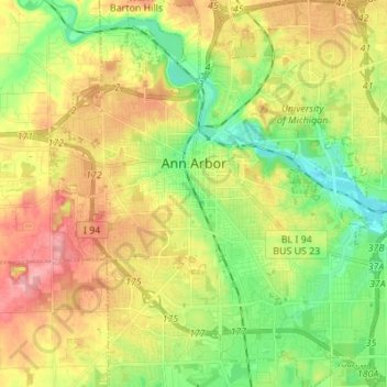
Nome: Mappa topografica Ann Arbor, altitudine, rilievo.
Luogo: Ann Arbor, Washtenaw County, Michigan, United States (42.22267 -83.79957 42.32389 -83.67581)
Altitudine media: 268 m
Altitudine minima: 223 m
Altitudine massima: 326 m
Fai una donazione
Preparati per la tua prossima avventura:
In qualità di associato Amazon, questo sito riceve una commissione sugli acquisti idonei senza alcun costo aggiuntivo per te.
Altre mappe topografiche
Clicca su una mappa per visualizzarne la topografia, l'altitudine e il rilievo.
Rawsonville
United States > Michigan > Washtenaw County > Ypsilanti Charter Township
Altitudine media: 214 m
Rawsonville
United States > Michigan > Washtenaw County > Ypsilanti Charter Township
Altitudine media: 214 m
Mooreville
United States > Michigan > Washtenaw County > York Charter Township
Altitudine media: 222 m
Fai una donazione
Preparati per la tua prossima avventura:
In qualità di associato Amazon, questo sito riceve una commissione sugli acquisti idonei senza alcun costo aggiuntivo per te.
Rawsonville
United States > Michigan > Washtenaw County > Ypsilanti Charter Township
Altitudine media: 214 m
Frain Lake
United States > Michigan > Washtenaw County > Superior Charter Township
Altitudine media: 259 m