
Fai una donazione
Preparati per la tua prossima avventura:
In qualità di associato Amazon, questo sito riceve una commissione sugli acquisti idonei senza alcun costo aggiuntivo per te.
Mappa topografica Mica
Clicca sulla mappa per visualizzare l'altitudine.
Fai una donazione
Preparati per la tua prossima avventura:
In qualità di associato Amazon, questo sito riceve una commissione sugli acquisti idonei senza alcun costo aggiuntivo per te.
A proposito di questa mappa
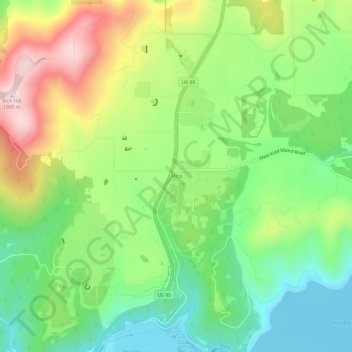
Nome: Mappa topografica Mica, altitudine, rilievo.
Luogo: Mica, Kootenai County, Idaho, 83814, United States (47.60046 -116.89130 47.64046 -116.85130)
Altitudine media: 785 m
Altitudine minima: 644 m
Altitudine massima: 1.003 m
Fai una donazione
Preparati per la tua prossima avventura:
In qualità di associato Amazon, questo sito riceve una commissione sugli acquisti idonei senza alcun costo aggiuntivo per te.
Altre mappe topografiche
Clicca su una mappa per visualizzarne la topografia, l'altitudine e il rilievo.
Coeur d'Alene
United States > Idaho > Kootenai County
The city is located on the north shore of Lake Coeur d'Alene, near the outlet of the Spokane River, and is in the Northern Rockies ecoregion. Lake Coeur d'Alene is a natural dam-controlled lake that is 25 miles (40 km) long and 1 mile (1.6 km) to 3 miles (4.8 km) wide and fed by the Coeur d'Alene and Saint Joe…
Altitudine media: 719 m
Post Falls
United States > Idaho > Kootenai County
Post Falls features a varied and distinctive topography characterized by its placement on the Rathdrum Prairie, which lies at an elevation of approximately 2,182 feet (665 meters) above sea level. This prairie is surrounded by rolling hills and rugged terrain that gradually rise towards the nearby Rocky…
Altitudine media: 710 m
Coeur d'Alene
United States > Idaho > Kootenai County
The city is located on the north shore of Lake Coeur d'Alene, near the outlet of the Spokane River, and is in the Northern Rockies ecoregion. Lake Coeur d'Alene is a natural dam-controlled lake that is 25 miles (40 km) long and 1 mile (1.6 km) to 3 miles (4.8 km) wide and fed by the Coeur d'Alene and Saint Joe…
Altitudine media: 719 m
Fai una donazione
Preparati per la tua prossima avventura:
In qualità di associato Amazon, questo sito riceve una commissione sugli acquisti idonei senza alcun costo aggiuntivo per te.
Rathdrum
United States > Idaho > Kootenai County
Rathdrum is located on the Rathdrum Prairie at 47°48′30″N 116°53′33″W / 47.80833°N 116.89250°W / 47.80833; -116.89250 (47.808457, -116.892415), at an elevation of 2,211 feet (674 m) above sea level.
Altitudine media: 701 m
Spirit Lake
United States > Idaho > Kootenai County
Spirit Lake is located at 47°58′00″N 116°51′59″W / 47.966592°N 116.866383°W / 47.966592; -116.866383, at an elevation of 2,569 feet (783 m) above sea level.
Altitudine media: 780 m
Athol
United States > Idaho > Kootenai County
Athol is located at 47°56′46″N 116°42′26″W / 47.94611°N 116.70722°W / 47.94611; -116.70722 (47.946024, -116.707349), at an elevation of 2,392 feet (729 m) above sea level.
Altitudine media: 733 m
Fai una donazione
Preparati per la tua prossima avventura:
In qualità di associato Amazon, questo sito riceve una commissione sugli acquisti idonei senza alcun costo aggiuntivo per te.
Hayden
United States > Idaho > Kootenai County
According to the United States Census Bureau, the city has a total area of 9.61 square miles (24.89 km2), of which 9.60 square miles (24.86 km2) is land and 0.01 square miles (0.03 km2) is water. It lies at the southwestern end of Hayden Lake, and the elevation of the city is 2,287 feet (697 m) above sea level.
Altitudine media: 709 m
Post Falls
United States > Idaho > Kootenai County
Post Falls is located on the Rathdrum Prairie, along the Washington–Idaho border. It is bounded by Coeur d’Alene to the east, Stateline and the state of Washington to the west, and the Spokane River to the south. Post Falls is 20 miles (32 km) east of Spokane and approximately 100 miles (160 km) south of…
Altitudine media: 710 m
Coeur d'Alene
United States > Idaho > Kootenai County
The city is located on the north shore of Lake Coeur d'Alene, near the outlet of the Spokane River, and is in the Northern Rockies ecoregion. Lake Coeur d'Alene is a natural dam-controlled lake that is 25 miles (40 km) long and 1 mile (1.6 km) to 3 miles (4.8 km) wide and fed by the Coeur d'Alene and Saint Joe…
Altitudine media: 719 m
Fai una donazione
Preparati per la tua prossima avventura:
In qualità di associato Amazon, questo sito riceve una commissione sugli acquisti idonei senza alcun costo aggiuntivo per te.
Coeur d'Alene
United States > Idaho > Kootenai County
The city is located on the north shore of Lake Coeur d'Alene, near the outlet of the Spokane River, and is in the Northern Rockies ecoregion. Lake Coeur d'Alene is a natural dam-controlled lake that is 25 miles (40 km) long and 1 mile (1.6 km) to 3 miles (4.8 km) wide and fed by the Coeur d'Alene and Saint Joe…
Altitudine media: 719 m
Athol
United States > Idaho > Kootenai County
Athol is located at 47°56′46″N 116°42′26″W / 47.94611°N 116.70722°W / 47.94611; -116.70722 (47.946024, -116.707349), at an elevation of 2,392 feet (729 m) above sea level.
Altitudine media: 733 m
Fai una donazione
Preparati per la tua prossima avventura:
In qualità di associato Amazon, questo sito riceve una commissione sugli acquisti idonei senza alcun costo aggiuntivo per te.
Post Falls
United States > Idaho > Kootenai County
Post Falls is located on the Rathdrum Prairie, along the Washington–Idaho border. It is bounded by Coeur d’Alene to the east, Stateline and the state of Washington to the west, and the Spokane River to the south. Post Falls is 20 miles (32 km) east of Spokane and approximately 100 miles (160 km) south of…
Altitudine media: 710 m
Rathdrum
United States > Idaho > Kootenai County
Rathdrum is located on the Rathdrum Prairie at 47°48′30″N 116°53′33″W / 47.80833°N 116.89250°W / 47.80833; -116.89250 (47.808457, -116.892415), at an elevation of 2,211 feet (674 m) above sea level.
Altitudine media: 701 m