
Fai una donazione
Preparati per la tua prossima avventura:
In qualità di associato Amazon, questo sito riceve una commissione sugli acquisti idonei senza alcun costo aggiuntivo per te.
Mappa topografica Hoodoo Mountain
Clicca sulla mappa per visualizzare l'altitudine.
Fai una donazione
Preparati per la tua prossima avventura:
In qualità di associato Amazon, questo sito riceve una commissione sugli acquisti idonei senza alcun costo aggiuntivo per te.
Hoodoo Mountain
Hoodoo Mountain, sometimes referred to as Hoodoo Volcano, is a potentially active stratovolcano in the Northern Interior of British Columbia, Canada. It is located 25 kilometres (16 miles) northeast of the Alaska–British Columbia border on the north side of the Iskut River opposite of the mouth of the Craig River. With a summit elevation of 1,850 metres (6,070 feet) and a topographic prominence of 900 metres (3,000 feet), Hoodoo Mountain is one of many prominent peaks within the Boundary Ranges of the Coast Mountains. Its flat-topped summit is covered by an ice cap more than 100 metres (330 feet) thick and at least 3 kilometres (1.9 miles) in diameter. Two valley glaciers surrounding the northwestern and northeastern sides of the mountain have retreated significantly over the last hundred years. They both originate from a large icefield to the north and are the sources of two meltwater streams. These streams flow along the western and eastern sides of the volcano before draining into the Iskut River.
Fai una donazione
Preparati per la tua prossima avventura:
In qualità di associato Amazon, questo sito riceve una commissione sugli acquisti idonei senza alcun costo aggiuntivo per te.
A proposito di questa mappa
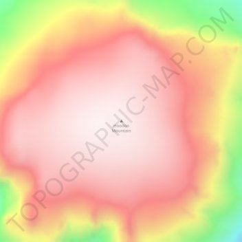
Nome: Mappa topografica Hoodoo Mountain, altitudine, rilievo.
Altitudine media: 1.657 m
Altitudine minima: 1.182 m
Altitudine massima: 1.855 m
Fai una donazione
Preparati per la tua prossima avventura:
In qualità di associato Amazon, questo sito riceve una commissione sugli acquisti idonei senza alcun costo aggiuntivo per te.
Altre mappe topografiche
Clicca su una mappa per visualizzarne la topografia, l'altitudine e il rilievo.
Tumeka Lake
Canada > British Columbia > Regional District of Kitimat-Stikine > Area D (Iskut/Big Raven)
Altitudine media: 1.382 m
Bob Quinn Lake
Canada > British Columbia > Regional District of Kitimat-Stikine > Area D (Iskut/Big Raven)
Altitudine media: 585 m
Ball Creek
Canada > British Columbia > Regional District of Kitimat-Stikine > Area D (Iskut/Big Raven)
Altitudine media: 1.228 m
Great Glacier
Canada > British Columbia > Regional District of Kitimat-Stikine > Area D (Iskut/Big Raven)
Altitudine media: 866 m
Fai una donazione
Preparati per la tua prossima avventura:
In qualità di associato Amazon, questo sito riceve una commissione sugli acquisti idonei senza alcun costo aggiuntivo per te.
Iskut River
Canada > British Columbia > Regional District of Kitimat-Stikine > Area D (Iskut/Big Raven)
Altitudine media: 932 m