
Mappa topografica Dover
Mappa interattiva
Clicca sulla mappa per visualizzare l'altitudine.
A proposito di questa mappa
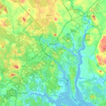
Nome: Mappa topografica Dover, altitudine, rilievo.
Luogo: Dover, Strafford County, New Hampshire, 03820, United States (43.11764 -70.96161 43.25498 -70.81902)
Altitudine media: 31 m
Altitudine minima: -9 m
Altitudine massima: 106 m
According to the United States Census Bureau, the city has a total area of 29.0 square miles (75.2 km2), of which 26.7 square miles (69.2 km2) are land and 2.3 square miles (6.0 km2) are water, comprising 7.97% of the city. Dover is drained by the Cochecho and Bellamy rivers, both of which flow into the tidal Piscataqua River, which forms the city's eastern boundary and the New Hampshire–Maine border. Long Hill, elevation greater than 300 feet (91 m) above sea level and located 3 miles (5 km) northwest of the city center, is the highest point in Dover. Garrison Hill, elevation approximately 290 ft (88 m), is a prominent hill rising directly above the center city, with a park and lookout tower on top.
Altre mappe topografiche
Clicca su una mappa per visualizzarne la topografia, l'altitudine e il rilievo.
Rollinsford
United States > New Hampshire > Strafford County
Rollinsford, Strafford County, New Hampshire, 03869, United States
Altitudine media: 32 m
Somersworth
United States > New Hampshire > Strafford County
Somersworth, Strafford County, New Hampshire, 03878, United States
Altitudine media: 56 m
New Durham
United States > New Hampshire > Strafford County
New Durham, Strafford County, New Hampshire, 03855, United States
Altitudine media: 228 m
Dover
United States > New Hampshire > Strafford County > Dover
Dover, Strafford County, New Hampshire, 03820, United States
Altitudine media: 52 m
Lee
United States > New Hampshire > Strafford County
Lee, Strafford County, New Hampshire, 03861, United States
Altitudine media: 47 m
Rochester
United States > New Hampshire > Strafford County > Rochester
Rochester, Strafford County, New Hampshire, United States
Altitudine media: 90 m