
Mappa topografica Gopeshwar
Clicca sulla mappa per visualizzare l'altitudine.
Gopeshwar
Gopeshwar is located at 30°25′N 79°20′E / 30.42°N 79.33°E / 30.42; 79.33. It has an average elevation of 1,450 m (4,760 ft). Gopeshwar is 8.4 km (5.2 mi) away from Chamoli which is located on the banks of Alaknanda river and along NH 58. Gopeshwar is able to captivate any visitor with its mystic charm and pristine beauty. There are multiple snow-capped hills and peaks visible from Gopeshwar.
A proposito di questa mappa
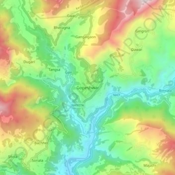
Nome: Mappa topografica Gopeshwar, altitudine, rilievo.
Luogo: Gopeshwar, Chamoli Tehsil, Chamoli, Uttarakhand, 246401, India (30.36878 79.27855 30.44878 79.35855)
Altitudine media: 1.566 m
Altitudine minima: 895 m
Altitudine massima: 2.725 m
Altre mappe topografiche
Clicca su una mappa per visualizzarne la topografia, l'altitudine e il rilievo.
Roopkund Lake
India > Uttarakhand > Chamoli Tehsil
Roopkund (locally known as Mystery Lake or Skeleton Lake) is a high altitude glacial lake in the Uttarakhand state of India. It lies in the lap of Trishul massif. Located in the Himalayas, the area around the lake is uninhabited and is roughly at an altitude of 5,020 metres (16,470 ft), surrounded by…
Altitudine media: 4.631 m