
Mappa topografica Church Crookham
Mappa interattiva
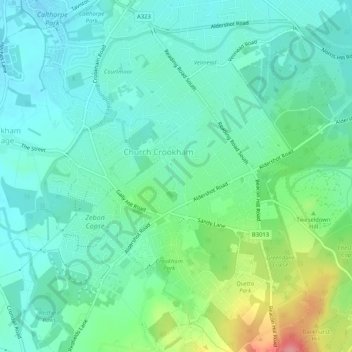
Clicca sulla mappa per visualizzare l'altitudine.
A proposito di questa mappa
Nome: Mappa topografica Church Crookham, altitudine, rilievo.
Altitudine media: 92 m
Altitudine minima: 66 m
Altitudine massima: 166 m
The parent sprawling parish of Crondall (in Crondall Hundred) was mostly rural at this time, with the 1831 edition of Samuel Lewis's Topographical Dictionary of England, which used the census returns to assess that Crookham had 623 inhabitants and not even mentioning the (at the time) much smaller Fleet. Other than Crondall tithing, this parish in 1800 consisted of four other tithings, Crookham (otherwise Church Crookham), Ewshot, Swanthorpe, and portions of Dippenhall (partly in Surrey, in Farnham Hundred). The soil is sandy here and in Ewshot, but is chalky in Swanthorpe and has some clay in other tithings.
Altre mappe topografiche
Clicca su una mappa per visualizzarne la topografia, l'altitudine e il rilievo.
Brookly Stream
United Kingdom > England > Hampshire > Hart > Fleet
Brookly Stream, Fleet, Hart, Hampshire, South East England, England, GU51 3RF, United Kingdom
Altitudine media: 78 m