Geolocalizza

Mappa topografica Farnborough

Clicca sulla mappa per visualizzare l'altitudine.

Farnborough

Farnborough is located in the northeastern corner of the county of Hampshire, near the border with Surrey. The town occupies a valley setting, with the main urban area situated between the River Blackwater to the east and higher ground to the west. The topography gradually rises from the valley floor, reaching a maximum elevation of around 90 metres (300 feet) above sea level on the fringes of the town.

Wikipedia (CC-BY-SA 3.0)

A proposito di questa mappa

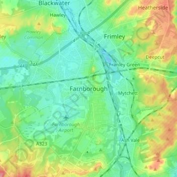
Nome: Mappa topografica Farnborough, altitudine, rilievo.

Luogo: Farnborough, Rushmoor, Hampshire, England, GU14 7JT, United Kingdom (51.25187 -0.79398 51.33187 -0.71398)

Altitudine media: 82 m

Altitudine minima: 57 m

Altitudine massima: 137 m

Preparati per la tua prossima avventura:

🧤Guanti da trekking - Protezione e comfort in tutte le stagioni
🏔️Abbigliamento da montagna - Indumenti tecnici per alta quota
🚲Accessori bici trekking - Equipaggiamento per cicloturismo
🧼Sapone Biodegradabile - Detergenti ecologici per rispettare l'ambiente durante il lavaggio
📷Action Camera - Videocamere resistenti per filmare discese in bici o scalate

In qualità di associato Amazon, questo sito riceve una commissione sugli acquisti idonei senza alcun costo aggiuntivo per te.