
Mappa topografica Mount Olympus
Clicca sulla mappa per visualizzare l'altitudine.
Mount Olympus
With notable local relief, Mount Olympus ascends over 2,100 m (6,900 ft) from the 293 m (961 ft) elevation confluence of the Hoh River with Glacier Creek in only 8.8 km (5.5 mi). Mount Olympus has 2,386 m (7,828 ft) of prominence, ranking 5th in the state of Washington.
A proposito di questa mappa
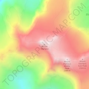
Nome: Mappa topografica Mount Olympus, altitudine, rilievo.
Luogo: Mount Olympus, Jefferson County, Washington, United States (47.80117 -123.71096 47.80127 -123.71086)
Altitudine media: 1.934 m
Altitudine minima: 1.337 m
Altitudine massima: 2.396 m
Altre mappe topografiche
Clicca su una mappa per visualizzarne la topografia, l'altitudine e il rilievo.
Hoh River
United States > Washington > Jefferson County
The Hoh River Trail, managed by the National Park Service, begins at the national park's Hoh Rain Forest Visitor Center at the end of the Upper Hoh Road. The trail follows the Hoh River east into the heart of the park. After 17.5 mi (28.2 km) it reaches Glacier Meadows near Mount Olympus's Blue Glacier. The…
Altitudine media: 534 m
Hoh River
United States > Washington > Jefferson County
The Hoh River Trail, managed by the National Park Service, begins at the national park's Hoh Rain Forest Visitor Center at the end of the Upper Hoh Road. The trail follows the Hoh River east into the heart of the park. After 17.5 mi (28.2 km) it reaches Glacier Meadows near Mount Olympus's Blue Glacier. The…
Altitudine media: 531 m
Fort Townsend Historical State Park
United States > Washington > Jefferson County
Altitudine media: 57 m