
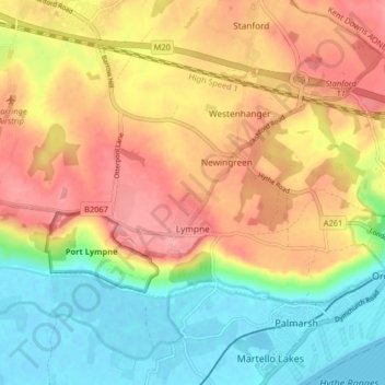
Mappa topografica Lympne
Mappa interattiva
Clicca sulla mappa per visualizzare l'altitudine.
A proposito di questa mappa
Nome: Mappa topografica Lympne, altitudine, rilievo.
Altitudine media: 56 m
Altitudine minima: -2 m
Altitudine massima: 113 m
Altre mappe topografiche
Clicca su una mappa per visualizzarne la topografia, l'altitudine e il rilievo.
Hythe
United Kingdom > England > Kent > Folkestone and Hythe District
Hythe, Folkestone and Hythe District, Kent, England, United Kingdom
Altitudine media: 32 m
Folkestone
United Kingdom > England > Kent > Folkestone and Hythe District
Folkestone, Folkestone and Hythe District, Kent, England, United Kingdom
Altitudine media: 62 m
Park Gate
United Kingdom > England > Kent > Folkestone and Hythe District > Elham
Park Gate, Elham, Folkestone and Hythe District, Kent, England, CT4 6BH, United Kingdom
Altitudine media: 130 m
Littlestone on Sea
United Kingdom > England > Kent > Folkestone and Hythe District > New Romney
Littlestone on Sea, New Romney, Folkestone and Hythe District, Kent, England, TN28 8QU, United Kingdom
Altitudine media: 1 m
Densole
United Kingdom > England > Kent > Folkestone and Hythe District
Densole, Folkestone and Hythe District, Kent, England, CT18 7BE, United Kingdom
Altitudine media: 146 m