
Mappa topografica Cherrapunji (Sohra)
Mappa interattiva
Clicca sulla mappa per visualizzare l'altitudine.
A proposito di questa mappa
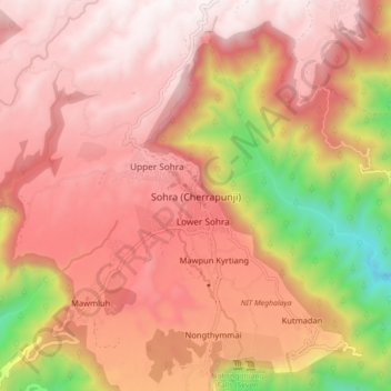
Nome: Mappa topografica Cherrapunji (Sohra), altitudine, rilievo.
Altitudine media: 1.248 m
Altitudine minima: 332 m
Altitudine massima: 1.677 m
It has an average elevation of 1,430 metres (4,690 ft) and sits on a plateau in the southern part of the Khasi Hills, facing the plains of Bangladesh. The plateau rises 660 meters above the surrounding valleys.