
Fai una donazione
Preparati per la tua prossima avventura:
In qualità di associato Amazon, questo sito riceve una commissione sugli acquisti idonei senza alcun costo aggiuntivo per te.
Mappa topografica Sesquicentennial State Park
Clicca sulla mappa per visualizzare l'altitudine.
Fai una donazione
Preparati per la tua prossima avventura:
In qualità di associato Amazon, questo sito riceve una commissione sugli acquisti idonei senza alcun costo aggiuntivo per te.
Sesquicentennial State Park
This park offers three picnic shelters, four picnic pads, and 84 campsites that vary in amenities & sizes. The park provides rental fishing boats, paddle boats, standup paddleboards, kayaks, canoes, fishing access to the 30-acre (12 ha) park lake, and four trails providing over 12 miles (19 km) of recreational access. The Sandhills Trail is an ADA-accessible two-mile (3.2 km) loop around the park lake. The Bike Trail is 6.5 miles (10.5 km) of moderate sandy terrain with several changes in elevation. Sesqui is the only South Carolina State Park that offers a full-scale splash pad and a membership-only dog park that allows dogs to run off-leash. The park office sells firewood, ice, t-shirts, and novelty Gifts.
Fai una donazione
Preparati per la tua prossima avventura:
In qualità di associato Amazon, questo sito riceve una commissione sugli acquisti idonei senza alcun costo aggiuntivo per te.
A proposito di questa mappa
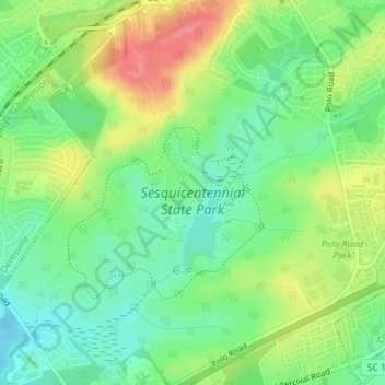
Nome: Mappa topografica Sesquicentennial State Park, altitudine, rilievo.
Altitudine media: 97 m
Altitudine minima: 67 m
Altitudine massima: 141 m
Fai una donazione
Preparati per la tua prossima avventura:
In qualità di associato Amazon, questo sito riceve una commissione sugli acquisti idonei senza alcun costo aggiuntivo per te.
Altre mappe topografiche
Clicca su una mappa per visualizzarne la topografia, l'altitudine e il rilievo.
Columbia
United States > South Carolina > Richland County
Columbia features a relatively gentle and rolling topography. The elevation in this area varies, with the city itself situated around 318 feet above sea level, while the surrounding regions exhibit elevations that can reach as high as 573 feet. The landscape is characterized by a mix of low-lying areas and…
Altitudine media: 89 m
Forest I At Harbison
United States > South Carolina > Richland County > Columbia
Altitudine media: 87 m
Fai una donazione
Preparati per la tua prossima avventura:
In qualità di associato Amazon, questo sito riceve una commissione sugli acquisti idonei senza alcun costo aggiuntivo per te.
Fai una donazione
Preparati per la tua prossima avventura:
In qualità di associato Amazon, questo sito riceve una commissione sugli acquisti idonei senza alcun costo aggiuntivo per te.
Columbia
United States > South Carolina > Richland County
The city has capitalized on this location, which includes three rivers, by identifying as "The Columbia Riverbanks Region". Columbia is located roughly halfway between the Atlantic Ocean and the Blue Ridge Mountains, at an elevation around 292 ft (89 m).
Altitudine media: 89 m
Fai una donazione
Preparati per la tua prossima avventura:
In qualità di associato Amazon, questo sito riceve una commissione sugli acquisti idonei senza alcun costo aggiuntivo per te.
Columbia
United States > South Carolina > Richland County
The city has capitalized on this location, which includes three rivers, by identifying as "The Columbia Riverbanks Region". Columbia is located roughly halfway between the Atlantic Ocean and the Blue Ridge Mountains, at an elevation around 292 ft (89 m).
Altitudine media: 89 m
Fai una donazione
Preparati per la tua prossima avventura:
In qualità di associato Amazon, questo sito riceve una commissione sugli acquisti idonei senza alcun costo aggiuntivo per te.
Forest I At Harbison
United States > South Carolina > Richland County > Columbia
Altitudine media: 87 m
Riverbanks
United States > South Carolina > Richland County > Columbia > Riverbanks
Altitudine media: 69 m
Fai una donazione
Preparati per la tua prossima avventura:
In qualità di associato Amazon, questo sito riceve una commissione sugli acquisti idonei senza alcun costo aggiuntivo per te.