
Fai una donazione
Preparati per la tua prossima avventura:
In qualità di associato Amazon, questo sito riceve una commissione sugli acquisti idonei senza alcun costo aggiuntivo per te.
Mappa topografica Jackson
Clicca sulla mappa per visualizzare l'altitudine.
Fai una donazione
Preparati per la tua prossima avventura:
In qualità di associato Amazon, questo sito riceve una commissione sugli acquisti idonei senza alcun costo aggiuntivo per te.
Jackson
The topography is hilly, with high points at over 1,200 feet (370 m) on Mount Harris and other peaks to the north, remnants of the Appalachian chain. The land area of the township is mostly forested, primarily a second growth northern mixed hardwood forest dominated by ash, poplar, oak, maple, pine, cedar, spruce, tamarack (larch) and hemlock. Forestry and livestock farming are the largest land uses, with hay the most common crop, corn silage the second most common. There are areas that have never been managed or cultivated, particularly bogs and remnant primeval forest in which large pine, hemlock and spruce trees predominate.
Fai una donazione
Preparati per la tua prossima avventura:
In qualità di associato Amazon, questo sito riceve una commissione sugli acquisti idonei senza alcun costo aggiuntivo per te.
A proposito di questa mappa
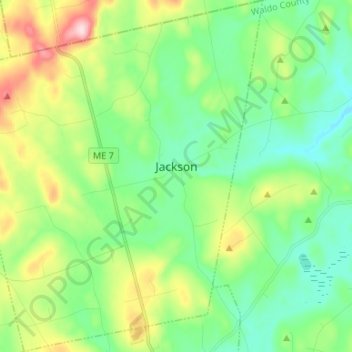
Nome: Mappa topografica Jackson, altitudine, rilievo.
Luogo: Jackson, Waldo County, Maine, United States (44.56493 -69.20425 44.65932 -69.08863)
Altitudine media: 157 m
Altitudine minima: 70 m
Altitudine massima: 360 m
Fai una donazione
Preparati per la tua prossima avventura:
In qualità di associato Amazon, questo sito riceve una commissione sugli acquisti idonei senza alcun costo aggiuntivo per te.
Altre mappe topografiche
Clicca su una mappa per visualizzarne la topografia, l'altitudine e il rilievo.