
Fai una donazione
Preparati per la tua prossima avventura:
In qualità di associato Amazon, questo sito riceve una commissione sugli acquisti idonei senza alcun costo aggiuntivo per te.
Mappa topografica Mariposa
Clicca sulla mappa per visualizzare l'altitudine.
Fai una donazione
Preparati per la tua prossima avventura:
In qualità di associato Amazon, questo sito riceve una commissione sugli acquisti idonei senza alcun costo aggiuntivo per te.
Mariposa
Mariposa is located at 37°29′06″N 119°57′59″W / 37.48500°N 119.96639°W / 37.48500; -119.96639, at 1,949 feet (594 m) in elevation. It lies in the rugged foothills of the Sierra Nevada. Mariposa Creek flows through the town. Soils in the urban area are mostly brown to reddish brown loam of the Blasingame series. A gravelly loam is mapped as the Boomer series. These soils support thick grassland plus trees such as blue oak, black oak, gray pine, and ponderosa pine. To the west-northwest of town is a large area of sparse vegetation and rockland on which is found serpentine soil of the Henneke series.
Fai una donazione
Preparati per la tua prossima avventura:
In qualità di associato Amazon, questo sito riceve una commissione sugli acquisti idonei senza alcun costo aggiuntivo per te.
A proposito di questa mappa
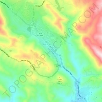
Nome: Mappa topografica Mariposa, altitudine, rilievo.
Altitudine media: 686 m
Altitudine minima: 537 m
Altitudine massima: 917 m
Fai una donazione
Preparati per la tua prossima avventura:
In qualità di associato Amazon, questo sito riceve una commissione sugli acquisti idonei senza alcun costo aggiuntivo per te.