
Mappa topografica Reisach
Clicca sulla mappa per visualizzare l'altitudine.
Reisach
Birklmühle | Bodendorf | Bronn | Buchau | Büchenbach | Großkrausmühle | Haidmühle | Hainbronn | Hammerbühl | Hedelmühle | Heroldsreuth | Herrenmühle | Hollenberg | Horlach | Hufeisen-Waldhaus | Kaltenthal | Kleinkrausmühle | Körbeldorf | Kosbrunn | Kotzenhammer | Langenreuth | Lehm | Leups | Leupsermühle | Lobensteig | Lüglas | Nemschenreuth | Neudorf | Neuhof | Oberhauenstein | Pegnitz (Kernbereich) | Penzenreuth | Pertenhof | Reisach | Rosenhof | Scharthammer | Stein | Stemmenreuth | Trockau | Troschenreuth | Unterhauenstein | Vestenmühle | Weidelwangermühle | Weidmannshöhe | Willenberg | Willenreuth | Wolfslohe | Ziegelhütte | Zips
A proposito di questa mappa
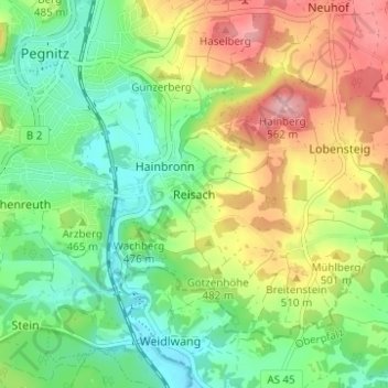
Nome: Mappa topografica Reisach, altitudine, rilievo.
Altitudine media: 466 m
Altitudine minima: 403 m
Altitudine massima: 564 m