
Mappa topografica Okinawa Island
Mappa interattiva
Clicca sulla mappa per visualizzare l'altitudine.
A proposito di questa mappa
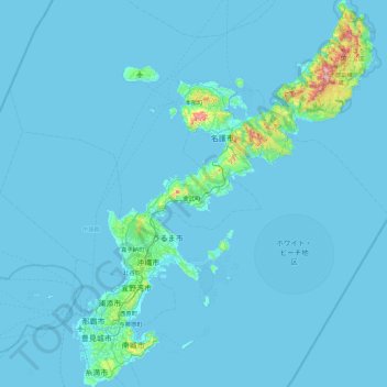
Nome: Mappa topografica Okinawa Island, altitudine, rilievo.
Luogo: Okinawa Island, Okinawa Prefecture, Japan (26.07446 127.62856 26.87552 128.32764)
Altitudine media: 14 m
Altitudine minima: 0 m
Altitudine massima: 483 m
The Motobu Peninsula in the north has limestone layers and karst development. In the center and south is mainly a Ryukyu limestone layer and mudstone. The topography is flat, there are few hills over 100 m (328 ft) with very few rivers. The subtropical rains accelerate erosion so there are many drainages and uvala. The southern end of the island consists of uplifted coral reef, whereas the northern half has proportionally more igneous rock. The easily eroded limestone of the south has many caves, the most famous of which is Gyokusendō in Nanjō. The northernmost Cape Hedo is only 22 km (14 mi) away from Yoronjima. Cape Arasaki is the southernmost location of Okinawa island. It is sometimes confused with Cape Kiyanmisaki.
Altre mappe topografiche
Clicca su una mappa per visualizzarne la topografia, l'altitudine e il rilievo.
Mount Fuji
Japan > Sunto County > Oyama
Mount Fuji, Oyama, Sunto County, Shizuoka Prefecture, Chubu Region, Japan
Altitudine media: 3.261 m
Lake Sanaru
Lake Sanaru, Hamamatsu, Shizuoka Prefecture, Chubu Region, Japan
Altitudine media: 16 m
Motoyama
Motoyama, Nagaoka County, Kochi Prefecture, 781-3601, Japan
Altitudine media: 679 m
Setouchi
Setouchi, Oshima County, Kagoshima Prefecture, Japan
Altitudine media: 26 m
Higashishirakawa
Higashishirakawa, Kamo County, Gifu Prefecture, Chubu Region, 509-1392, Japan
Altitudine media: 658 m
Nishikigaoka-chuo Park
Nishikigaoka-chuo Park, Nishikigaoka 2-chome, Aoba Ward, Sendai, Miyagi Prefecture, Japan
Altitudine media: 197 m
Katsura Imperial Villa
Katsura Imperial Villa, Road No. 142, Katsura-Kasugacho, Nishikyo Ward, Kyoto, Kyoto Prefecture, 615-8013, Japan
Altitudine media: 25 m