
Mappa topografica Warwick
Mappa interattiva
Clicca sulla mappa per visualizzare l'altitudine.
A proposito di questa mappa
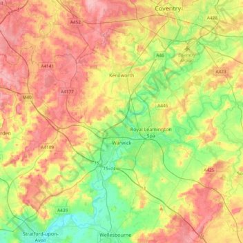
Nome: Mappa topografica Warwick, altitudine, rilievo.
Luogo: Warwick, Warwickshire, West Midlands, England, United Kingdom (52.21370 -1.78018 52.38928 -1.40608)
Altitudine media: 87 m
Altitudine minima: 35 m
Altitudine massima: 145 m
Warwick experiences the usual English maritime climate, marked by a narrow temperature range, mild winters and cool summers. The nearest official Met Office weather station is at Wellesbourne, about 6 miles (10 km) south of the town centre and at a similar elevation.
Altre mappe topografiche
Clicca su una mappa per visualizzarne la topografia, l'altitudine e il rilievo.
Warwick Castle
United Kingdom > England > Warwickshire > Warwick
Warwick Castle, Northern Tower, Cliff Hill, Warwick, Warwickshire, England, CV34 4QX, United Kingdom
Altitudine media: 56 m
Sherbourne
United Kingdom > England > Warwickshire > Warwick
Sherbourne, Warwick, Warwickshire, England, United Kingdom
Altitudine media: 56 m
Leek Wootton
United Kingdom > England > Warwickshire > Warwick
Leek Wootton, Warwick, Warwickshire, England, CV35 7RS, United Kingdom
Altitudine media: 76 m