
Mappa topografica Wolfstein
Clicca sulla mappa per visualizzare l'altitudine.
Wolfstein
Altenhof | Auhof | Autobahnmeisterei Neumarkt i.d.OPf. | Beckenmühle | Blomenhof | Bodenhof | Bodenmühle | Eichenmühle | Frickenhofen | Friedlmühle | Fuchsberg | Großwiesenhof | Guglhof | Habersmühle | Helena | Höhenberg | Höhenberg im Tal | Holzheim | Iberlsmühle | Ischhofen | Karhof | Kohlenbrunnermühle | Koppenmühle | Labersricht | Lähr | Lampertshofen | Lippertshofen | Neumarkt in der Oberpfalz | Ottosau | Pelchenhofen | Pölling | Rittershof | Rödelberg | Schafhof | Schleifmühle | Schmermühle | Schönmühle | Stauf | Steinberg | Tiefenbrunn | Ungenricht | Voggenthal | Woffenbach | Wolfstein | Wolfstein
A proposito di questa mappa
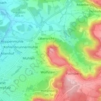
Nome: Mappa topografica Wolfstein, altitudine, rilievo.
Altitudine media: 471 m
Altitudine minima: 405 m
Altitudine massima: 598 m