
Fai una donazione
Preparati per la tua prossima avventura:
In qualità di associato Amazon, questo sito riceve una commissione sugli acquisti idonei senza alcun costo aggiuntivo per te.
Mappa topografica Trent Lakes
Clicca sulla mappa per visualizzare l'altitudine.
Fai una donazione
Preparati per la tua prossima avventura:
In qualità di associato Amazon, questo sito riceve una commissione sugli acquisti idonei senza alcun costo aggiuntivo per te.
Trent Lakes
The lumber and agricultural industries are significant to the history of the township. Due to the topography of the region, agricultural production was limited to only certain areas where soil conditions were adequate and cattle and mixed farming (orchards, cattle, horses, sheep, grains, vegetables, chickens and turkeys) were the predominant formats. Lumber production in the area led to the construction of standing timber lumber camps, with the numerous waterways allowing the transport of that lumber to production and processing mills in the area. This led to the development of settlements of forestry workers, but non-resident lumber barons took most of the gains from the industry. With the decline of the lumber industry, the settlements in the region also grew less populous. The French Canadians, Irish immigrants and other lumber labourers moved to other thriving locations, leaving smaller groups in the region. Galway, Cavendish and Harvey wards all have ghost settlements and nearly-forgotten communities including Silver Lake, Rockcroft, Scotts Mills, Fortesque. Following World War II, the area became popular as a camping and cottaging area.
Fai una donazione
Preparati per la tua prossima avventura:
In qualità di associato Amazon, questo sito riceve una commissione sugli acquisti idonei senza alcun costo aggiuntivo per te.
A proposito di questa mappa
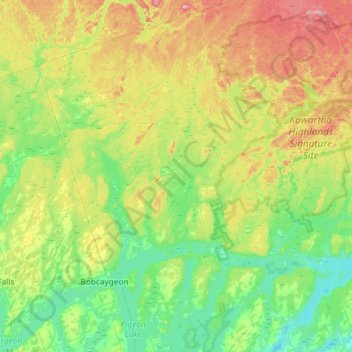
Nome: Mappa topografica Trent Lakes, altitudine, rilievo.
Altitudine media: 293 m
Altitudine minima: 230 m
Altitudine massima: 432 m
Fai una donazione
Preparati per la tua prossima avventura:
In qualità di associato Amazon, questo sito riceve una commissione sugli acquisti idonei senza alcun costo aggiuntivo per te.
Altre mappe topografiche
Clicca su una mappa per visualizzarne la topografia, l'altitudine e il rilievo.
Millbrook
Canada > Ontario > Peterborough County > Cavan-Monaghan
Peterborough's topography is largely defined by land formations created by the receding Wisconsian glaciers 10,000–15,000 years ago. The South End and Downtown portions of the city sit on what was the bottom of the glacial Lake Peterborough—part of a glacial spillway created when glacial meltwaters from…
Altitudine media: 250 m
Fai una donazione
Preparati per la tua prossima avventura:
In qualità di associato Amazon, questo sito riceve una commissione sugli acquisti idonei senza alcun costo aggiuntivo per te.
Fai una donazione
Preparati per la tua prossima avventura:
In qualità di associato Amazon, questo sito riceve una commissione sugli acquisti idonei senza alcun costo aggiuntivo per te.
Mount Pleasant
Canada > Ontario > Peterborough County > Cavan-Monaghan > Mount Pleasant
Altitudine media: 280 m
Fai una donazione
Preparati per la tua prossima avventura:
In qualità di associato Amazon, questo sito riceve una commissione sugli acquisti idonei senza alcun costo aggiuntivo per te.
Fai una donazione
Preparati per la tua prossima avventura:
In qualità di associato Amazon, questo sito riceve una commissione sugli acquisti idonei senza alcun costo aggiuntivo per te.
Villiers
Canada > Ontario > Peterborough County > Otonabee–South Monaghan > Villiers
Altitudine media: 225 m
Fai una donazione
Preparati per la tua prossima avventura:
In qualità di associato Amazon, questo sito riceve una commissione sugli acquisti idonei senza alcun costo aggiuntivo per te.
Cordova Mines
Canada > Ontario > Peterborough County > Havelock-Belmont-Methuen
Altitudine media: 209 m
Fai una donazione
Preparati per la tua prossima avventura:
In qualità di associato Amazon, questo sito riceve una commissione sugli acquisti idonei senza alcun costo aggiuntivo per te.
Millbrook
Canada > Ontario > Peterborough County > Cavan-Monaghan
Peterborough's topography is largely defined by land formations created by the receding Wisconsian glaciers 10,000–15,000 years ago. The South End and Downtown portions of the city sit on what was the bottom of the glacial Lake Peterborough—part of a glacial spillway created when glacial meltwaters from…
Altitudine media: 250 m