
Fai una donazione
Preparati per la tua prossima avventura:
In qualità di associato Amazon, questo sito riceve una commissione sugli acquisti idonei senza alcun costo aggiuntivo per te.
Mappa topografica Mount Pleasant
Clicca sulla mappa per visualizzare l'altitudine.
Fai una donazione
Preparati per la tua prossima avventura:
In qualità di associato Amazon, questo sito riceve una commissione sugli acquisti idonei senza alcun costo aggiuntivo per te.
Mount Pleasant
Mount Pleasant occupies a very low, gently undulating Lowcountry setting on the South Carolina Coastal Plain, where the town spreads across interfluves and former island-like uplands between the Cooper River, the Wando River, Charleston Harbor, Shem Creek, tidal creeks, and the Intracoastal Waterway. Its relief is subdued, with most built-up areas lying only a few feet to a few tens of feet above sea level, while the slightly higher inland ridges and neighborhood plateaus rise modestly above surrounding marshes and drainage corridors. The broader Charleston area is described as a drowned coastal-plain landscape with dendritic tidal drainage, this explains Mount Pleasant’s strongly water-shaped terrain, where broad salt marshes, creek valleys, low bluffs, filled or modified waterfronts, and sandy barrier-island margins toward Sullivan’s Island and Isle of Palms define the physical character of the landscape. Overall, the topography is flat to gently rolling, open, estuarine, and flood-prone, with elevation contrasts expressed less as hills than as subtle transitions from marsh and tidal flats to slightly raised coastal terraces and developed uplands.
Fai una donazione
Preparati per la tua prossima avventura:
In qualità di associato Amazon, questo sito riceve una commissione sugli acquisti idonei senza alcun costo aggiuntivo per te.
A proposito di questa mappa
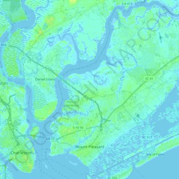
Nome: Mappa topografica Mount Pleasant, altitudine, rilievo.
Altitudine media: 3 m
Altitudine minima: -4 m
Altitudine massima: 19 m
Fai una donazione
Preparati per la tua prossima avventura:
In qualità di associato Amazon, questo sito riceve una commissione sugli acquisti idonei senza alcun costo aggiuntivo per te.
Altre mappe topografiche
Clicca su una mappa per visualizzarne la topografia, l'altitudine e il rilievo.
Hobcaw Point
United States > South Carolina > Charleston County > Mount Pleasant
Altitudine media: 4 m
Fai una donazione
Preparati per la tua prossima avventura:
In qualità di associato Amazon, questo sito riceve una commissione sugli acquisti idonei senza alcun costo aggiuntivo per te.
Saint Andrews Heights
United States > South Carolina > Charleston County > Charleston
Altitudine media: 5 m
Pinewood Vista
United States > South Carolina > Charleston County > North Charleston
Altitudine media: 9 m
Palmetto Fort
United States > South Carolina > Charleston County > Mount Pleasant
Altitudine media: 4 m
Fai una donazione
Preparati per la tua prossima avventura:
In qualità di associato Amazon, questo sito riceve una commissione sugli acquisti idonei senza alcun costo aggiuntivo per te.
Fenwick Crossroads
United States > South Carolina > Charleston County > Charleston
Altitudine media: 5 m
Jamestown Estates
United States > South Carolina > Charleston County > James Island
Altitudine media: 4 m
Fai una donazione
Preparati per la tua prossima avventura:
In qualità di associato Amazon, questo sito riceve una commissione sugli acquisti idonei senza alcun costo aggiuntivo per te.
Brook Green Meadow
United States > South Carolina > Charleston County > Mount Pleasant
Altitudine media: 4 m
Fai una donazione
Preparati per la tua prossima avventura:
In qualità di associato Amazon, questo sito riceve una commissione sugli acquisti idonei senza alcun costo aggiuntivo per te.
Fai una donazione
Preparati per la tua prossima avventura:
In qualità di associato Amazon, questo sito riceve una commissione sugli acquisti idonei senza alcun costo aggiuntivo per te.
Fai una donazione
Preparati per la tua prossima avventura:
In qualità di associato Amazon, questo sito riceve una commissione sugli acquisti idonei senza alcun costo aggiuntivo per te.
Remleys Point
United States > South Carolina > Charleston County > Mount Pleasant
Altitudine media: 4 m
Camp Saint Christopher
United States > South Carolina > Charleston County > Seabrook Island
Altitudine media: 2 m
North Charleston Wannamaker County Park
United States > South Carolina > Charleston County > North Charleston
Altitudine media: 8 m
Fai una donazione
Preparati per la tua prossima avventura:
In qualità di associato Amazon, questo sito riceve una commissione sugli acquisti idonei senza alcun costo aggiuntivo per te.
Fai una donazione
Preparati per la tua prossima avventura:
In qualità di associato Amazon, questo sito riceve una commissione sugli acquisti idonei senza alcun costo aggiuntivo per te.
Forest Park
United States > South Carolina > Charleston County > Charleston > Maryville
Altitudine media: 5 m
Fai una donazione
Preparati per la tua prossima avventura:
In qualità di associato Amazon, questo sito riceve una commissione sugli acquisti idonei senza alcun costo aggiuntivo per te.
Liberty Hill
United States > South Carolina > Charleston County > North Charleston
Altitudine media: 7 m
Wando Estates
United States > South Carolina > Charleston County > Mount Pleasant
Altitudine media: 5 m
Fai una donazione
Preparati per la tua prossima avventura:
In qualità di associato Amazon, questo sito riceve una commissione sugli acquisti idonei senza alcun costo aggiuntivo per te.
Fai una donazione
Preparati per la tua prossima avventura:
In qualità di associato Amazon, questo sito riceve una commissione sugli acquisti idonei senza alcun costo aggiuntivo per te.
Saint Andrews Heights
United States > South Carolina > Charleston County > Charleston
Altitudine media: 5 m
Ashley Junction
United States > South Carolina > Charleston County > North Charleston
Altitudine media: 7 m
Camp Saint Christopher
United States > South Carolina > Charleston County > Seabrook Island
Altitudine media: 2 m
Fai una donazione
Preparati per la tua prossima avventura:
In qualità di associato Amazon, questo sito riceve una commissione sugli acquisti idonei senza alcun costo aggiuntivo per te.
North Charleston
United States > South Carolina > Charleston County > North Charleston
Altitudine media: 5 m
Country Club Estates
United States > South Carolina > Charleston County > Charleston
Altitudine media: 3 m
Fai una donazione
Preparati per la tua prossima avventura:
In qualità di associato Amazon, questo sito riceve una commissione sugli acquisti idonei senza alcun costo aggiuntivo per te.
Deerwood Heights
United States > South Carolina > Charleston County > North Charleston
Altitudine media: 8 m
Northwood Estates
United States > South Carolina > Charleston County > North Charleston > Northwood Estates
Altitudine media: 8 m