
Mappa topografica Lawson
Clicca sulla mappa per visualizzare l'altitudine.
Lawson
In 1931, the Railway Department agreed to supply electricity to the Blue Mountains Shire Council. Power lines were constructed between Blackheath and Lawson, accompanied by a maintenance track. The authorities then decided to promote the maintenance track as a walking trail; it became known as Bruce's Walk, after the surveyor who planned it. The track later became neglected and forgotten, until it was rediscovered and improved by bushwalkers in the 1980s. It can now be followed from Medlow Bath to the north side of Lawson, although it is not shown on the relevant topographic map.
A proposito di questa mappa
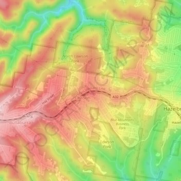
Nome: Mappa topografica Lawson, altitudine, rilievo.
Altitudine media: 684 m
Altitudine minima: 535 m
Altitudine massima: 790 m
Altre mappe topografiche
Clicca su una mappa per visualizzarne la topografia, l'altitudine e il rilievo.
Prospect Hill
Australia > New South Wales > Sydney
As at 19 February 2001, the Prospect Hill area had state significance due to its unique combination of significant landscape feature, potential archaeological site, and association with important historical phases. As a dolerite outcrop rising to a height of 117 metres (384 ft) AHD , Prospect Hill is a rare…
Altitudine media: 65 m
Sydney Observatory
Australia > New South Wales > Sydney
The place has an association with an extensive array of historical figures most of whom have helped shape its fabric. These include: colonial Governors Hunter, Bligh, Macquarie & Denison; military officers and engineers Macarthur; Barrallier; Bellasis and Minchin; convicts: the as yet unnamed constructors of…
Altitudine media: 14 m