
Mappa topografica Englewood
Clicca sulla mappa per visualizzare l'altitudine.
Englewood
Englewood features predominantly flat and low-lying terrain typical of the region's coastal landscape. The average elevation here is approximately 15 feet above sea level, which makes the area particularly susceptible to tidal influences and storm surges. The terrain is interspersed with wetlands and mangrove habitats, contributing to the region's biodiversity. Along the coastline, sandy beaches stretch along the Gulf of Mexico, offering picturesque views and recreational opportunities. Overall, Englewood’s landscape is characterized by its gentle topography, which supports both residential developments and natural ecosystems.
A proposito di questa mappa
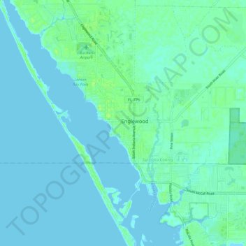
Nome: Mappa topografica Englewood, altitudine, rilievo.
Luogo: Englewood, Sarasota County, Florida, 34223, United States (26.91775 -82.40342 27.00477 -82.29851)
Altitudine media: 3 m
Altitudine minima: -5 m
Altitudine massima: 11 m