
Fai una donazione
Preparati per la tua prossima avventura:
In qualità di associato Amazon, questo sito riceve una commissione sugli acquisti idonei senza alcun costo aggiuntivo per te.
Mappa topografica Tabernash
Clicca sulla mappa per visualizzare l'altitudine.
Fai una donazione
Preparati per la tua prossima avventura:
In qualità di associato Amazon, questo sito riceve una commissione sugli acquisti idonei senza alcun costo aggiuntivo per te.
Tabernash
On August 10, 1984, a Cessna L-19 Bird Dog (registration N4584A), piloted by James Jeb Caddell, 36, crashed in a forest near Tabernash. The aircraft was en route from Granby to Jeffco Airport, Colorado. The wreckage was found by backpackers three years later on August 23, 1987. A 6½ minute video shot from a VHS camcorder mounted on the instrument panel was found at the site. The heavily damaged tape, some of it hanging from tree branches, was recovered and repaired by Colorado deputy sheriff Dale Wood. Subsequent analysis of the footage revealed that the pilot had not taken into account the density altitude conditions that existed on the day of the flight. The aircraft was unable to climb away from steadily rising terrain. In an attempt to return to the departure airfield, the pneumatic stall warning of the airplane sounded three times during a turn to the right. The pilot could be heard yelling, "Damn, hang on Ronnie!" to his one backseat passenger, Ronald Hugh Wilmond, 36, three seconds before impacting the terrain and trees.
Fai una donazione
Preparati per la tua prossima avventura:
In qualità di associato Amazon, questo sito riceve una commissione sugli acquisti idonei senza alcun costo aggiuntivo per te.
A proposito di questa mappa
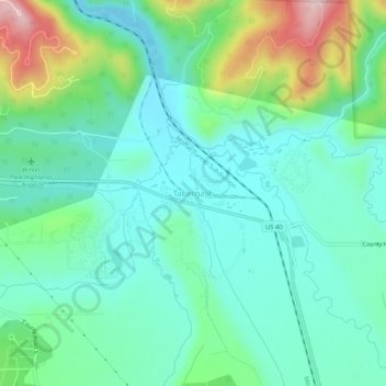
Nome: Mappa topografica Tabernash, altitudine, rilievo.
Luogo: Tabernash, Grand County, Colorado, 80478, United States (39.97360 -105.86307 40.01360 -105.82307)
Altitudine media: 2.592 m
Altitudine minima: 2.519 m
Altitudine massima: 2.802 m
Fai una donazione
Preparati per la tua prossima avventura:
In qualità di associato Amazon, questo sito riceve una commissione sugli acquisti idonei senza alcun costo aggiuntivo per te.
Altre mappe topografiche
Clicca su una mappa per visualizzarne la topografia, l'altitudine e il rilievo.
Fraser
United States > Colorado > Grand County
Fraser is located in southeastern Grand County at 39°56′39″N 105°48′48″W / 39.94417°N 105.81333°W / 39.94417; -105.81333 (39.944158, -105.813355), at an elevation of 8,574 feet (2,613 m) above sea level. It is bordered to the south by the town of Winter Park and to the north by…
Altitudine media: 2.696 m
Fai una donazione
Preparati per la tua prossima avventura:
In qualità di associato Amazon, questo sito riceve una commissione sugli acquisti idonei senza alcun costo aggiuntivo per te.
Hot Sulphur Springs
United States > Colorado > Grand County
Hot Sulphur Springs is a statutory town and the county seat of Grand County, Colorado, United States. The town is located near Byers Canyon between Granby and Kremmling, 95 miles (153 km) northwest of Denver and 30 miles (48 km) northwest of Winter Park. The town population was 687 at the 2020 census. Its…
Altitudine media: 2.446 m