
Fai una donazione
Preparati per la tua prossima avventura:
In qualità di associato Amazon, questo sito riceve una commissione sugli acquisti idonei senza alcun costo aggiuntivo per te.
Mappa topografica Digos
Clicca sulla mappa per visualizzare l'altitudine.
Fai una donazione
Preparati per la tua prossima avventura:
In qualità di associato Amazon, questo sito riceve una commissione sugli acquisti idonei senza alcun costo aggiuntivo per te.
Digos
The land topography of Digos City ranges from hilly to mountainous in the north-northeast portion and flat and slightly rolling at the coastal barangays, while the urban area and the surrounding barangays in the south portion are generally flat. Generally, climate in Digos falls under the fourth type while wind direction is prevalent from northeast to southwest. On the other hand, rainfall is evenly distributed throughout the year wherein during the period from 1995 to 2000, there was no observed extreme dry or wet season.
Fai una donazione
Preparati per la tua prossima avventura:
In qualità di associato Amazon, questo sito riceve una commissione sugli acquisti idonei senza alcun costo aggiuntivo per te.
A proposito di questa mappa
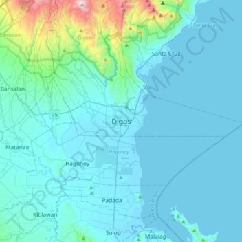
Nome: Mappa topografica Digos, altitudine, rilievo.
Luogo: Digos, Davao del Sur, Davao Region, 8002, Philippines (6.58438 125.19563 6.90438 125.51563)
Altitudine media: 152 m
Altitudine minima: -4 m
Altitudine massima: 1.652 m
Fai una donazione
Preparati per la tua prossima avventura:
In qualità di associato Amazon, questo sito riceve una commissione sugli acquisti idonei senza alcun costo aggiuntivo per te.