
Mappa topografica Sanquhar
Mappa interattiva
Clicca sulla mappa per visualizzare l'altitudine.
A proposito di questa mappa
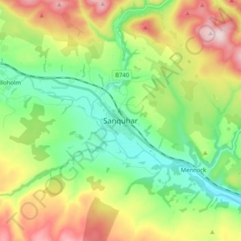
Nome: Mappa topografica Sanquhar, altitudine, rilievo.
Altitudine media: 243 m
Altitudine minima: 102 m
Altitudine massima: 487 m
Altre mappe topografiche
Clicca su una mappa per visualizzarne la topografia, l'altitudine e il rilievo.
Gillesbie
United Kingdom > Scotland > Dumfries and Galloway > Boreland
Gillesbie, Boreland, Dumfries and Galloway, Scotland, DG11 2LF, United Kingdom
Altitudine media: 195 m
Holywood
United Kingdom > Scotland > Dumfries and Galloway
Holywood, Dumfries and Galloway, Scotland, DG2 0RE, United Kingdom
Altitudine media: 26 m
Lockerbie
United Kingdom > Scotland > Dumfries and Galloway
Lockerbie, Dumfries and Galloway, Scotland, DG11 2EU, United Kingdom
Altitudine media: 96 m
Ley Hill
United Kingdom > Scotland > Dumfries and Galloway
Ley Hill, Dumfries and Galloway, Scotland, DG11 3HG, United Kingdom
Altitudine media: 214 m
Cairnryan
United Kingdom > Scotland > Dumfries and Galloway > Cairnryan
Cairnryan, Dumfries and Galloway, Scotland, DG9 8RB, United Kingdom
Altitudine media: 64 m
Drummore
United Kingdom > Scotland > Dumfries and Galloway
Drummore, Dumfries and Galloway, Scotland, DG9 9PY, United Kingdom
Altitudine media: 36 m