
Mappa topografica Odell
Mappa interattiva
Clicca sulla mappa per visualizzare l'altitudine.
A proposito di questa mappa
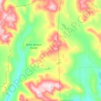
Nome: Mappa topografica Odell, altitudine, rilievo.
Luogo: Odell, Coös County, New Hampshire, United States (44.65996 -71.44437 44.79573 -71.32428)
Altitudine media: 673 m
Altitudine minima: 368 m
Altitudine massima: 1.114 m
A substantial portion of the state-owned Nash Stream Forest lies within the township. There are three mountains, each having elevations above 3,000 feet (910 m): Muise Mountain, Whitcomb Mountain and Long Mountain, whose two summits are the two highest points in Odell, at 3,661 feet (1,116 m) above sea level each. There are only a few rough roads and no highways here.