
Fai una donazione
Preparati per la tua prossima avventura:
In qualità di associato Amazon, questo sito riceve una commissione sugli acquisti idonei senza alcun costo aggiuntivo per te.
Mappa topografica Charleston
Clicca sulla mappa per visualizzare l'altitudine.
Fai una donazione
Preparati per la tua prossima avventura:
In qualità di associato Amazon, questo sito riceve una commissione sugli acquisti idonei senza alcun costo aggiuntivo per te.
Charleston
Charleston is characterized by its relatively flat topography, with an average elevation of about 10 feet above sea level, making it prone to flooding during heavy rains and storms. The city is situated on a peninsula bordered by the Ashley River to the west and the Cooper River to the east, creating a natural harbor that has historically contributed to its significance as a port city. The terrain includes a mix of marshlands, low-lying coastal areas, and sandy beaches, particularly along the nearby islands of Folly Beach and Sullivan's Island. This coastal environment is complemented by an intricate system of waterways, creeks, and tidal estuaries, which support diverse ecosystems and provide recreational opportunities for residents and visitors alike. The area's rich soil and mild climate further enhance its lush vegetation, contributing to the charm of Charleston's historic gardens and parks.
Fai una donazione
Preparati per la tua prossima avventura:
In qualità di associato Amazon, questo sito riceve una commissione sugli acquisti idonei senza alcun costo aggiuntivo per te.
A proposito di questa mappa
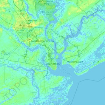
Nome: Mappa topografica Charleston, altitudine, rilievo.
Luogo: Charleston, Charleston County, South Carolina, United States (32.66851 -80.14385 32.97352 -79.79706)
Altitudine media: 4 m
Altitudine minima: -5 m
Altitudine massima: 23 m
Fai una donazione
Preparati per la tua prossima avventura:
In qualità di associato Amazon, questo sito riceve una commissione sugli acquisti idonei senza alcun costo aggiuntivo per te.
Altre mappe topografiche
Clicca su una mappa per visualizzarne la topografia, l'altitudine e il rilievo.
Hobcaw Point
United States > South Carolina > Charleston County > Mount Pleasant
Altitudine media: 4 m
Fai una donazione
Preparati per la tua prossima avventura:
In qualità di associato Amazon, questo sito riceve una commissione sugli acquisti idonei senza alcun costo aggiuntivo per te.
Saint Andrews Heights
United States > South Carolina > Charleston County > Charleston
Altitudine media: 5 m
Pinewood Vista
United States > South Carolina > Charleston County > North Charleston
Altitudine media: 9 m
Palmetto Fort
United States > South Carolina > Charleston County > Mount Pleasant
Altitudine media: 4 m
Fai una donazione
Preparati per la tua prossima avventura:
In qualità di associato Amazon, questo sito riceve una commissione sugli acquisti idonei senza alcun costo aggiuntivo per te.
Fenwick Crossroads
United States > South Carolina > Charleston County > Charleston
Altitudine media: 5 m
Jamestown Estates
United States > South Carolina > Charleston County > James Island
Altitudine media: 4 m
Fai una donazione
Preparati per la tua prossima avventura:
In qualità di associato Amazon, questo sito riceve una commissione sugli acquisti idonei senza alcun costo aggiuntivo per te.
Brook Green Meadow
United States > South Carolina > Charleston County > Mount Pleasant
Altitudine media: 4 m
Fai una donazione
Preparati per la tua prossima avventura:
In qualità di associato Amazon, questo sito riceve una commissione sugli acquisti idonei senza alcun costo aggiuntivo per te.
Fai una donazione
Preparati per la tua prossima avventura:
In qualità di associato Amazon, questo sito riceve una commissione sugli acquisti idonei senza alcun costo aggiuntivo per te.
Fai una donazione
Preparati per la tua prossima avventura:
In qualità di associato Amazon, questo sito riceve una commissione sugli acquisti idonei senza alcun costo aggiuntivo per te.
Remleys Point
United States > South Carolina > Charleston County > Mount Pleasant
Altitudine media: 4 m
Camp Saint Christopher
United States > South Carolina > Charleston County > Seabrook Island
Altitudine media: 2 m
North Charleston Wannamaker County Park
United States > South Carolina > Charleston County > North Charleston
Altitudine media: 8 m
Fai una donazione
Preparati per la tua prossima avventura:
In qualità di associato Amazon, questo sito riceve una commissione sugli acquisti idonei senza alcun costo aggiuntivo per te.
Fai una donazione
Preparati per la tua prossima avventura:
In qualità di associato Amazon, questo sito riceve una commissione sugli acquisti idonei senza alcun costo aggiuntivo per te.
Forest Park
United States > South Carolina > Charleston County > Charleston > Maryville
Altitudine media: 5 m
Fai una donazione
Preparati per la tua prossima avventura:
In qualità di associato Amazon, questo sito riceve una commissione sugli acquisti idonei senza alcun costo aggiuntivo per te.
Liberty Hill
United States > South Carolina > Charleston County > North Charleston
Altitudine media: 7 m
Wando Estates
United States > South Carolina > Charleston County > Mount Pleasant
Altitudine media: 5 m
Fai una donazione
Preparati per la tua prossima avventura:
In qualità di associato Amazon, questo sito riceve una commissione sugli acquisti idonei senza alcun costo aggiuntivo per te.
Fai una donazione
Preparati per la tua prossima avventura:
In qualità di associato Amazon, questo sito riceve una commissione sugli acquisti idonei senza alcun costo aggiuntivo per te.
Saint Andrews Heights
United States > South Carolina > Charleston County > Charleston
Altitudine media: 5 m
Ashley Junction
United States > South Carolina > Charleston County > North Charleston
Altitudine media: 7 m
Camp Saint Christopher
United States > South Carolina > Charleston County > Seabrook Island
Altitudine media: 2 m
Fai una donazione
Preparati per la tua prossima avventura:
In qualità di associato Amazon, questo sito riceve una commissione sugli acquisti idonei senza alcun costo aggiuntivo per te.
North Charleston
United States > South Carolina > Charleston County > North Charleston
Altitudine media: 5 m
Country Club Estates
United States > South Carolina > Charleston County > Charleston
Altitudine media: 3 m
Fai una donazione
Preparati per la tua prossima avventura:
In qualità di associato Amazon, questo sito riceve una commissione sugli acquisti idonei senza alcun costo aggiuntivo per te.
Deerwood Heights
United States > South Carolina > Charleston County > North Charleston
Altitudine media: 8 m
Northwood Estates
United States > South Carolina > Charleston County > North Charleston > Northwood Estates
Altitudine media: 8 m