
Fai una donazione
Preparati per la tua prossima avventura:
In qualità di associato Amazon, questo sito riceve una commissione sugli acquisti idonei senza alcun costo aggiuntivo per te.
Mappa topografica Umbrella Rock
Clicca sulla mappa per visualizzare l'altitudine.
Fai una donazione
Preparati per la tua prossima avventura:
In qualità di associato Amazon, questo sito riceve una commissione sugli acquisti idonei senza alcun costo aggiuntivo per te.
A proposito di questa mappa
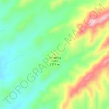
Nome: Mappa topografica Umbrella Rock, altitudine, rilievo.
Altitudine media: 2.168 m
Altitudine minima: 2.082 m
Altitudine massima: 2.314 m
Fai una donazione
Preparati per la tua prossima avventura:
In qualità di associato Amazon, questo sito riceve una commissione sugli acquisti idonei senza alcun costo aggiuntivo per te.
Altre mappe topografiche
Clicca su una mappa per visualizzarne la topografia, l'altitudine e il rilievo.
Gallup
United States > New Mexico > McKinley County
Gallup, like most of the interior Mountain West, has a cool semiarid climate (Köppen BSk). The summers are hot during the day, but the high altitude and low humidity mean that nights remain distinctly cool; as late as July 2, 1997, the temperature fell to 31 °F (−1 °C). Despite the large diurnal…
Altitudine media: 2.067 m
Ramah
United States > New Mexico > McKinley County > Ramah
Lying at 6926 feet above sea level, Ramah is considered by some as a high desert, but at higher elevations in includes tall pines, sandstone cliffs, and timber covered mountains. Much of the lower landscape in the surrounding area is covered with lava flows from the chain of volcanos to the south. Intermixed…
Altitudine media: 2.184 m
Fai una donazione
Preparati per la tua prossima avventura:
In qualità di associato Amazon, questo sito riceve una commissione sugli acquisti idonei senza alcun costo aggiuntivo per te.
Ramah
United States > New Mexico > McKinley County > Ramah
Lying at 6,926 feet (2,111 m) above sea level, Ramah is considered by some as a high desert, but at higher elevations it includes tall pines, sandstone cliffs, and timber-covered mountains. Much of the lower landscape in the surrounding area is covered with lava flows from the chain of volcanos to the south.
Altitudine media: 2.184 m
Fai una donazione
Preparati per la tua prossima avventura:
In qualità di associato Amazon, questo sito riceve una commissione sugli acquisti idonei senza alcun costo aggiuntivo per te.
Gallup
United States > New Mexico > McKinley County
Gallup, like most of the interior Mountain West, has a cool semiarid climate (Köppen BSk). The summers are hot during the day, but the high altitude and low humidity mean that nights remain distinctly cool; as late as July 2, 1997, the temperature fell to 31 °F (−1 °C). Despite the large diurnal…
Altitudine media: 2.067 m
Fai una donazione
Preparati per la tua prossima avventura:
In qualità di associato Amazon, questo sito riceve una commissione sugli acquisti idonei senza alcun costo aggiuntivo per te.
Crownpoint
United States > New Mexico > McKinley County
Crownpoint is in central McKinley County along New Mexico State Road 371, which leads south 23 miles (37 km) to Thoreau and Interstate 40, and north 83 miles (134 km) to Farmington. The community sits at an elevation of 6,851 feet (2,088 m) on land that drains toward the Chaco River 30 miles (48 km) to the…
Altitudine media: 2.099 m