
Mappa topografica Westchester
Mappa interattiva
Clicca sulla mappa per visualizzare l'altitudine.
A proposito di questa mappa
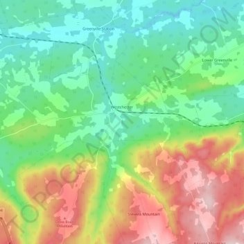
Nome: Mappa topografica Westchester, altitudine, rilievo.
Altitudine media: 157 m
Altitudine minima: 55 m
Altitudine massima: 331 m
Altre mappe topografiche
Clicca su una mappa per visualizzarne la topografia, l'altitudine e il rilievo.
West Amherst
Canada > Nova Scotia > Municipality of the County of Cumberland
West Amherst, Municipality of the County of Cumberland, Cumberland County, Nova Scotia, B4H 3Y4, Canada
Altitudine media: 13 m
Mapleton
Canada > Nova Scotia > Municipality of the County of Cumberland
Mapleton, Municipality of the County of Cumberland, Cumberland County, Nova Scotia, B0M 1W0, Canada
Altitudine media: 102 m
Beckwith
Canada > Nova Scotia > Municipality of the County of Cumberland
Beckwith, Municipality of the County of Cumberland, Cumberland County, Nova Scotia, Canada
Altitudine media: 44 m
Northport
Canada > Nova Scotia > Municipality of the County of Cumberland
Northport, Municipality of the County of Cumberland, Cumberland County, Nova Scotia, B0L 1E0, Canada
Altitudine media: 12 m
Maccan
Canada > Nova Scotia > Municipality of the County of Cumberland
Maccan, Municipality of the County of Cumberland, Cumberland County, Nova Scotia, B0L 1B0, Canada
Altitudine media: 45 m
Parrsboro
Canada > Nova Scotia > Municipality of the County of Cumberland
Parrsboro, Municipality of the County of Cumberland, Cumberland County, Nova Scotia, B0M 1S0, Canada
Altitudine media: 25 m
Gulf Shore
Canada > Nova Scotia > Municipality of the County of Cumberland > Gulf Shore
Gulf Shore, Municipality of the County of Cumberland, Cumberland County, Nova Scotia, B0K 1L0, Canada
Altitudine media: 11 m