
Fai una donazione
Preparati per la tua prossima avventura:
In qualità di associato Amazon, questo sito riceve una commissione sugli acquisti idonei senza alcun costo aggiuntivo per te.
Mappa topografica Grand Lake o' the Cherokees
Clicca sulla mappa per visualizzare l'altitudine.
Fai una donazione
Preparati per la tua prossima avventura:
In qualità di associato Amazon, questo sito riceve una commissione sugli acquisti idonei senza alcun costo aggiuntivo per te.
Grand Lake o' the Cherokees
Grand Lake has a surface area of 41,779 acres (169.07 km2) of water, a storage volume of 1,515,416 acre-feet, and 1,366 miles (2,198 km) of shoreline. Unlike other lakes in Oklahoma, Grand Lake is a deep and mostly rocky lake. The average depth for Grand Lake is 36.3 feet. Its mean elevation is 745 ft (227 m) above sea level. In recent years, low fall elevations of 741 were kept by the GRDA to allow millet seeding for migratory waterfowl, resulting in conflict between property owners, environmentalists, and federal agencies. While not expressly built for flood control, Grand Lake contributes to the flood-prone Arkansas River watershed. The Army Corps of Engineers controls releases into the McClellan-Kerr Arkansas River Navigation System when lake levels exceed 745 feet (227 m), although locking into Grand Lake is not possible. Grand Lake and its neighbor, Lake Hudson (also managed by the GRDA), are the only two major lakes in the state where one can build directly on the waterfront.
Fai una donazione
Preparati per la tua prossima avventura:
In qualità di associato Amazon, questo sito riceve una commissione sugli acquisti idonei senza alcun costo aggiuntivo per te.
A proposito di questa mappa
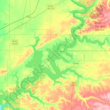
Nome: Mappa topografica Grand Lake o' the Cherokees, altitudine, rilievo.
Altitudine media: 257 m
Altitudine minima: 190 m
Altitudine massima: 358 m
Fai una donazione
Preparati per la tua prossima avventura:
In qualità di associato Amazon, questo sito riceve una commissione sugli acquisti idonei senza alcun costo aggiuntivo per te.