
Fai una donazione
Preparati per la tua prossima avventura:
In qualità di associato Amazon, questo sito riceve una commissione sugli acquisti idonei senza alcun costo aggiuntivo per te.
Mappa topografica Kolguyev Island
Clicca sulla mappa per visualizzare l'altitudine.
Fai una donazione
Preparati per la tua prossima avventura:
In qualità di associato Amazon, questo sito riceve una commissione sugli acquisti idonei senza alcun costo aggiuntivo per te.
Kolguyev Island
The island was explored in 1894 by the British naturalist Aubyn B.R. Trevor-Battye. He landed in June with an assistant, intending to spend about one month studying the wildlife, especially the birds. Due to mechanical problems with the vessel and a misunderstanding, they were left stranded on the island for 12 weeks. He published his study of the natural history and topography of Kolguyev as: "Ice-bound on Kolguev" (Trevor-Battye 1895). The book includes observations on the Nenets (whom he called Samoyed) who brought their reindeer to the island for summer grazing and to trap geese for trade in Russia. Trevor-Battye eventually left the island with these reindeer herders in September 1894, and had to travel 1,000 miles (1,600 km) overland from the Pechora River to Archangel. He described this adventurous journey in: "A northern highway of the Tsar" (Trevor-Battye 1898).
Fai una donazione
Preparati per la tua prossima avventura:
In qualità di associato Amazon, questo sito riceve una commissione sugli acquisti idonei senza alcun costo aggiuntivo per te.
A proposito di questa mappa
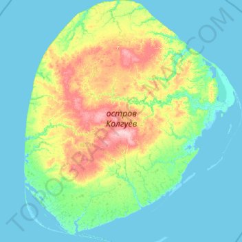
Nome: Mappa topografica Kolguyev Island, altitudine, rilievo.
Altitudine media: 26 m
Altitudine minima: -5 m
Altitudine massima: 176 m
Fai una donazione
Preparati per la tua prossima avventura:
In qualità di associato Amazon, questo sito riceve una commissione sugli acquisti idonei senza alcun costo aggiuntivo per te.
Altre mappe topografiche
Clicca su una mappa per visualizzarne la topografia, l'altitudine e il rilievo.
Vaygach polar station
Russia > Nenets Autonomous Okrug > Zapolyarny District
Vaygach Island is mainly formed of argillaceous slates, sandstone, and limestone. There are many rivers about 20–40 kilometres (12–25 mi) in length, swamps, and small lakes on the island. For the most part it consists of tundra. Slight rocky ridges run generally along its length, and the coast has low…
Altitudine media: 12 m