
Fai una donazione
Preparati per la tua prossima avventura:
In qualità di associato Amazon, questo sito riceve una commissione sugli acquisti idonei senza alcun costo aggiuntivo per te.
Mappa topografica Highland State Recreation Area
Clicca sulla mappa per visualizzare l'altitudine.
Fai una donazione
Preparati per la tua prossima avventura:
In qualità di associato Amazon, questo sito riceve una commissione sugli acquisti idonei senza alcun costo aggiuntivo per te.
Highland State Recreation Area
West of Duck Lake Road in Highland State Recreation Area, a group of small moraines are locally called "mountains"—the highest elevation in the park, Mount Kanzer, is 1,150 feet (350 m) above sea level. The highland for which this recreation area is named is this group of moraines.
Fai una donazione
Preparati per la tua prossima avventura:
In qualità di associato Amazon, questo sito riceve una commissione sugli acquisti idonei senza alcun costo aggiuntivo per te.
A proposito di questa mappa
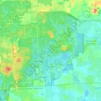
Nome: Mappa topografica Highland State Recreation Area, altitudine, rilievo.
Altitudine media: 302 m
Altitudine minima: 282 m
Altitudine massima: 355 m
Fai una donazione
Preparati per la tua prossima avventura:
In qualità di associato Amazon, questo sito riceve una commissione sugli acquisti idonei senza alcun costo aggiuntivo per te.