
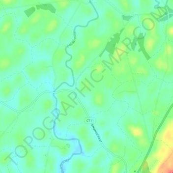
Mappa topografica Brattan's Hill
Mappa interattiva
Clicca sulla mappa per visualizzare l'altitudine.
A proposito di questa mappa
Nome: Mappa topografica Brattan's Hill, altitudine, rilievo.
Altitudine media: 79 m
Altitudine minima: 62 m
Altitudine massima: 115 m
Altre mappe topografiche
Clicca su una mappa per visualizzarne la topografia, l'altitudine e il rilievo.
Brookeborough
United Kingdom > Northern Ireland > County Fermanagh
Brookeborough, County Fermanagh, Northern Ireland, BT94 4EZ, United Kingdom
Altitudine media: 97 m
White Island
United Kingdom > Northern Ireland > County Fermanagh
White Island, County Fermanagh, Ulster, Northern Ireland, United Kingdom
Altitudine media: 48 m
Lough Navar
United Kingdom > Northern Ireland > County Fermanagh
Lough Navar, Barr of Drumbadmeen, County Fermanagh, Ulster, Northern Ireland, United Kingdom
Altitudine media: 232 m
Carr
United Kingdom > Northern Ireland > County Fermanagh
Carr, County Fermanagh, Northern Ireland, United Kingdom
Altitudine media: 60 m
Ederney
United Kingdom > Northern Ireland > County Fermanagh
Ederney, County Fermanagh, Northern Ireland, BT93 0DG, United Kingdom
Altitudine media: 91 m
Tempo
United Kingdom > Northern Ireland > County Fermanagh > Tempo
Tempo, County Fermanagh, Northern Ireland, BT94 3LU, United Kingdom
Altitudine media: 127 m
Bellanaleck
United Kingdom > Northern Ireland > County Fermanagh
Bellanaleck, County Fermanagh, Ulster, Northern Ireland, BT92 2BA, United Kingdom
Altitudine media: 54 m
Irvinestown
United Kingdom > Northern Ireland > County Fermanagh
Irvinestown, County Fermanagh, Ulster, Northern Ireland, BT94 1GS, United Kingdom
Altitudine media: 95 m
Belcoo
United Kingdom > Northern Ireland > County Fermanagh
Belcoo, County Fermanagh, Ulster, Northern Ireland, BT93 5FB, United Kingdom
Altitudine media: 86 m
Derrygonnelly
United Kingdom > Northern Ireland > County Fermanagh
Derrygonnelly, County Fermanagh, Ulster, Northern Ireland, BT93 6HW, United Kingdom
Altitudine media: 79 m
Cuilcagh
United Kingdom > Northern Ireland > County Fermanagh
Cuilcagh, Cavan-Belturbet Municipal District, County Cavan, Ireland
Altitudine media: 472 m