
Mappa topografica Papeete
Mappa interattiva
Clicca sulla mappa per visualizzare l'altitudine.
A proposito di questa mappa
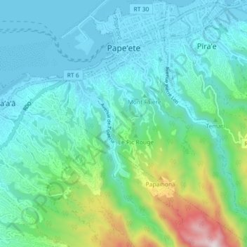
Nome: Mappa topografica Papeete, altitudine, rilievo.
Altitudine media: 224 m
Altitudine minima: -2 m
Altitudine massima: 1.133 m
Previously, during the construction of the Faʻaiere water tower with a capacity of 150,000 litres for the drinking water supply of the city of Papeʻetē, a difference in altitude of 37 metres (121 ft) was overcome with a light railway laid on a 220 metres (720 ft) long inclined plane. A winch driven by a 12-horsepower Fowler or Decauville locomobile carried three narrow gauge railway trucks at a time, consuming up to 200 kilograms (440 lb) of coal per day for about sixty journeys. Paul Decauville mentioned in a letter to Governor Theodore Lacascade, dated 18 June 1891, an order for "15 kilometres (9.3 mi) of 600 mm (1 ft 11+5⁄8 in) portable rail tracks and about 12,000 francs of rolling stock, payable in three years," presumably for a tramway from Papeʻetē to Punaʻauia operated by hand or animals.
Altre mappe topografiche
Clicca su una mappa per visualizzarne la topografia, l'altitudine e il rilievo.
Tahiti
France > French Polynesia > Windward Islands
Tahiti, Windward Islands, French Polynesia, France
Altitudine media: 160 m
Punaʻauiʻa
France > French Polynesia > Windward Islands
Punaʻauiʻa, Windward Islands, French Polynesia, France
Altitudine media: 215 m
Area
France > French Polynesia > Windward Islands > Taiarapu-Ouest
Area, Taiarapu-Ouest, Windward Islands, French Polynesia, France
Altitudine media: 229 m
Arue
France > French Polynesia > Windward Islands
Arue, Windward Islands, French Polynesia, 98701, France
Altitudine media: 14 m