
Mappa topografica Westmoreland
Mappa interattiva
Clicca sulla mappa per visualizzare l'altitudine.
A proposito di questa mappa
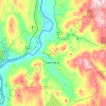
Nome: Mappa topografica Westmoreland, altitudine, rilievo.
Altitudine media: 228 m
Altitudine minima: 62 m
Altitudine massima: 465 m
According to the United States Census Bureau, the town has a total area of 36.8 square miles (95.4 km2), of which 35.8 square miles (92.7 km2) is land and 1.0 square mile (2.7 km2), or 2.80%, is water. Westmoreland is bounded on the west by the Connecticut River, which is the state border with Vermont. Hyland Hill, elevation 1,510 feet (460 m) and the highest point in town, is on the eastern border and although it is now private land, it is a local hiking and hunting destination.
Altre mappe topografiche
Clicca su una mappa per visualizzarne la topografia, l'altitudine e il rilievo.
Stoddard
United States > New Hampshire > Cheshire County
Stoddard, Cheshire County, New Hampshire, United States
Altitudine media: 451 m
Chesterfield
United States > New Hampshire > Cheshire County
Chesterfield, Cheshire County, New Hampshire, United States
Altitudine media: 229 m
Harrisville
United States > New Hampshire > Cheshire County
Harrisville, Cheshire County, New Hampshire, 03450, United States
Altitudine media: 422 m
Gilboa Mountain
United States > New Hampshire > Cheshire County > Westmoreland
Gilboa Mountain, Westmoreland, Cheshire County, New Hampshire, 03467, United States
Altitudine media: 331 m
Alstead
United States > New Hampshire > Cheshire County
Alstead, Cheshire County, New Hampshire, United States
Altitudine media: 289 m
West Chesterfield
United States > New Hampshire > Cheshire County > Chesterfield
West Chesterfield, Chesterfield, Cheshire County, New Hampshire, 03466, United States
Altitudine media: 168 m
Rindge
United States > New Hampshire > Cheshire County
Rindge, Cheshire County, New Hampshire, United States
Altitudine media: 343 m
Marlborough
United States > New Hampshire > Cheshire County
Marlborough, Cheshire County, New Hampshire, 03455, United States
Altitudine media: 299 m
Winchester
United States > New Hampshire > Cheshire County > Winchester
Winchester, Cheshire County, New Hampshire, United States
Altitudine media: 167 m
Pisgah State Park
United States > New Hampshire > Cheshire County > Winchester
Pisgah State Park, Winchester, Cheshire County, New Hampshire, United States
Altitudine media: 250 m
Keene
United States > New Hampshire > Cheshire County
Keene, Cheshire County, New Hampshire, United States
Altitudine media: 263 m
Harper Acres
United States > New Hampshire > Cheshire County > Keene
Harper Acres, Keene, Cheshire County, New Hampshire, 03431, United States
Altitudine media: 156 m
Fitzwilliam
United States > New Hampshire > Cheshire County
Fitzwilliam, Cheshire County, New Hampshire, 03447, United States
Altitudine media: 345 m
Jaffrey
United States > New Hampshire > Cheshire County
Jaffrey, Cheshire County, New Hampshire, 03452, United States
Altitudine media: 351 m
Monte Rosa
United States > New Hampshire > Cheshire County > Jaffrey
Monte Rosa, Jaffrey, Cheshire County, New Hampshire, United States
Altitudine media: 634 m